The Columbia Icefield: what it is and how to visit
What is the Columbia Icefield and when can you visit?
The Columbia Icefield is a glacier field straddling the Banff-Jasper boundary on the Icefields Parkway, best known for the Athabasca Glacier, its most accessible tongue. The Discovery Centre and its tours typically run from late April or May through October, closing for winter.
Where the ice meets the highway
The Columbia Icefield is the single biggest reason most people drive the full length of the Icefields Parkway rather than turning back at Peyto Lake. It sits almost exactly where Banff National Park gives way to Jasper, roughly 127 kilometres north of Lake Louise and 105 kilometres south of Jasper townsite, and it’s the one stop on the parkway that gets treated as a destination in its own right rather than a pullout.
“Columbia Icefield” refers to a large body of glacial ice, on the order of 200 square kilometres, sitting mostly out of sight on the high plateau above the highway. What you actually see and stand in front of from the road is the Athabasca Glacier, one of several tongues of ice that spill down from the icefield into the valley below. It’s the most visited and most photographed glacier in the Canadian Rockies, and for the overwhelming majority of visitors, it’s the only part of the Columbia Icefield they’ll ever set foot near.
The icefield feeds a genuinely unusual hydrological feature: meltwater from it drains into three different oceans, the Pacific, the Atlantic (via Hudson Bay), and the Arctic, by way of the Columbia, North Saskatchewan, and Athabasca river systems. That triple-watershed split is a geography curiosity worth knowing, though it isn’t something you can see from the viewing area; it’s a fact about where the water goes after it leaves, not a feature of the landscape itself.
Getting there and when it’s open
The Columbia Icefield sits directly on Highway 93 North, the Icefields Parkway, at the Columbia Icefield Discovery Centre. From Banff it’s about 180 kilometres, roughly 2 hours 15 minutes of driving with no shortcuts. From Jasper it’s closer, about 105 kilometres and 1 hour 15 minutes. Either way, budget for stops: this stretch of road passes Bow Lake and Crowfoot Glacier, the Peyto Lake viewpoint, and Sunwapta Falls, and few drivers pass all of them without pulling over at least once.
| From | Distance | Driving time |
|---|---|---|
| Banff | ~180 km | ~2 h 15 min |
| Lake Louise | ~127 km | ~1 h 30 min |
| Jasper | ~105 km | ~1 h 15 min |
The Discovery Centre and its two paid attractions run on a seasonal schedule, typically opening in late April or early May and closing by mid-October, depending on snow. Outside that window, both the Ice Explorer and the Glacier Skywalk are closed, though the highway may remain passable for through traffic between Banff and Jasper (see our Icefields Parkway in winter guide for what does and doesn’t operate off-season). Shoulder-season visitors, especially in early May or early October, should expect a real chance of a shortened schedule or a weather closure and should have a backup plan for the day.
There’s no gas station at the Discovery Centre itself; the nearest fuel in either direction depends on the season, so check our gas and cell coverage guide for the Icefields Parkway before you leave Lake Louise or Jasper. Cell service at the icefield is limited and unreliable.
Because the Icefields Parkway runs through both Banff and Jasper national parks, a valid Parks Canada pass is required for this stop, the same pass that covers the rest of the parkway — see our Parks Canada pass guide for current rates. The pass doesn’t cover the Ice Explorer or Glacier Skywalk tickets; those are booked and paid separately.
The Athabasca Glacier, and why it’s shrinking
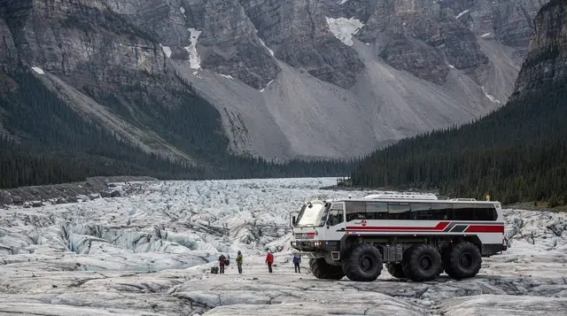
The Athabasca Glacier is what you’ll actually walk up toward from the parking area, and it’s worth seeing plainly before booking anything: a broad tongue of grey-white ice descending from the icefield above, streaked with rock debris and crossed by visible crevasses. Roadside and trailside markers along the access path show where the glacier’s toe stood in past decades, and the gap between those markers and the current ice edge tells the story better than any sign can.
The glacier has been retreating for well over a century, and current measurements put the average loss at roughly 5 metres of length a year, though the rate varies from year to year with snowfall and summer temperatures. That’s a broad, ongoing trend rather than something that changes visit to visit, and we cover the mechanics of why it’s happening, and what it means for the icefield longer term, in a dedicated guide on why the glaciers are retreating rather than getting into the detail here.
One thing this guide will say plainly: you cannot walk freely onto the Athabasca Glacier on your own. It looks approachable from the parking area, and every year people wander past the marked boundary anyway. Underneath a relatively smooth-looking surface, the glacier is cut by crevasses, some hidden under snow bridges that can collapse without warning under a person’s weight, and there have been fatalities from exactly this. Unsupervised access beyond the marked safe zone is not just against the rules, it’s genuinely dangerous, on ice that looks far more stable than it is.
How people actually get onto the ice
There are two sanctioned ways to get close to or onto the Athabasca Glacier, and this guide only summarizes them — each has its own dedicated page with the full detail on what to expect, what to wear, and how long it takes.
The most common option is the Ice Explorer, a purpose-built, oversized bus on tundra tires that drives directly out onto a section of the glacier cleared and monitored for safety, where passengers can get out and walk on the ice under supervision for a set amount of time. It’s the higher-volume, lower-effort option, and it’s what most Columbia Icefield day-trippers mean when they say they “went on the glacier.” See our Athabasca Glacier Ice Explorer guide for the full ride sequence, timing, and what the on-ice stop actually involves.
For a more physical alternative, small-group guided glacier hikes take visitors on foot, roped together with crampons and proper glacier travel gear, led by a certified mountain guide who knows where the crevasses are. This is a different experience entirely from the Ice Explorer: slower, farther onto the ice, and considerably more involved, but still firmly guided rather than a free walk. Our guided glacier walk guide explains what these trips typically cover and who they suit.
If you’d rather have both the driving and the ice walk handled for you, the day tour to the Columbia Icefield with a local guide bundles transport with the Ice Explorer experience, which removes the trickiest part of the day: getting to a remote stretch of highway and back without eating into the rest of your trip. For travellers who want the on-foot version instead of the vehicle tour, the guided glacier hike onto the Athabasca Glacier is the roped, on-foot alternative described above.
The Glacier Skywalk, and the combo ticket
A short shuttle ride from the Ice Explorer boarding area is the Glacier Skywalk, a glass-floored observation platform cantilevered about 280 metres above the Sunwapta Valley. It’s a separate attraction from the Athabasca Glacier itself — you’re not looking down at the glacier from it so much as out over the valley the glacier carved — and it doesn’t involve setting foot on ice at all. Our Glacier Skywalk guide has the full walk-through of what it’s like, how long to allow, and whether it’s worth it if heights aren’t your thing.
Because the two attractions sit close together and share a booking system, they’re most often sold as a combined ticket covering both the Ice Explorer ride and the Skywalk visit, alongside standalone tickets for either one on its own. Most first-time visitors buy the combo rather than choosing between them, since doing both in one day is straightforward from a logistics standpoint and the price difference over buying separately is modest. In peak summer, same-day tickets for either attraction can sell out by early afternoon, so booking online ahead of arrival is worth the ten minutes it takes.
The combined Columbia Icefield and Glacier Skywalk day tour from Jasper covers both stops with transport included, and the Columbia Icefield Discovery tour is a similar full-day option that also builds in stops at other points along the parkway between Jasper and the icefield.
What a visit actually involves
Plan for a half-day at minimum if you’re doing the Ice Explorer, the Skywalk, or both, once you account for driving to the Discovery Centre, parking, ticket lines, shuttle transfers between the two attractions, and the drive back onto your route. The Ice Explorer excursion itself, including the shuttle to and from the boarding area and the time out on the ice, typically runs 80 to 90 minutes; the Skywalk visit is shorter, often 30 to 45 minutes including the walk out and back.
Dress warmer than the temperature at the parking lot suggests. Wind funnels down off the ice field even on a sunny summer day, and the on-ice section of the Ice Explorer stop is noticeably colder than the drive up. A packable jacket is worth having even in July.
If you’re driving the Icefields Parkway in a single day between Lake Louise and Jasper, the Columbia Icefield stop is the one most likely to blow your schedule, since it’s easy to underestimate how long the Ice Explorer and Skywalk actually take once you’re queued up. Our guide on one day versus two days on the Icefields Parkway walks through the trade-off, and the stops-in-order guide shows where the icefield sits relative to everything else worth pulling over for.
Practical notes before you go
- Book tickets online ahead of time in July and August. The Discovery Centre’s walk-up ticket counter regularly sells out of same-day Ice Explorer and Skywalk slots by early afternoon in peak summer.
- Dress for wind, not just cold. The on-ice stop is exposed and consistently windier than the parking lot, even on a warm, still day down the highway.
- Fuel up before you arrive. There’s no gas station at the Discovery Centre, and the nearest reliable fuel depends on which direction you’re travelling from.
- Don’t rely on your phone once you’re there. Cell coverage is patchy to non-existent; download directions, tickets, and any maps you need before leaving Lake Louise or Jasper.
- Stay behind the marked boundary on the ice. The safe zone on the Ice Explorer stop and the sanctioned area for guided hikes exist because the rest of the glacier is genuinely hazardous, not as an overcautious formality.
- Build in more time than you think. Between the drive, parking, ticket lines, and the shuttle between the Ice Explorer and Skywalk, a “quick stop” at the Columbia Icefield easily fills half a day.
Combining it with the rest of the parkway
The Columbia Icefield rarely stands alone on an itinerary; it’s usually the anchor point of a longer day or a multi-day drive along the Icefields Parkway road trip route. Heading north from the icefield, Athabasca Falls and Sunwapta Falls are both short detours before reaching Jasper townsite, which continues to welcome visitors following the 2024 wildfire — see our note on Jasper after the fire if you’re wondering what to expect there. Heading south, the drive retraces the parkway’s lake stops back toward Lake Louise and Banff.
Frequently asked questions about the Columbia Icefield
Can you walk onto the Athabasca Glacier on your own?
Not safely, and Parks Canada actively discourages it. The glacier is riddled with hidden crevasses under snow bridges that can collapse without warning, and people have died walking out unguided. Visitors reach the ice either aboard a guided Ice Explorer vehicle or on foot with a certified glacier guide roped up with proper equipment.
How much has the Athabasca Glacier retreated?
The glacier has been retreating for well over a century and currently loses roughly 5 metres of length a year on average, with markers along the access trail showing where its edge stood in past decades. Our dedicated guide on why the glaciers are retreating covers the mechanics in more detail.
Do the Ice Explorer and the Glacier Skywalk cost the same ticket?
They’re sold both separately and as a combined ticket, and most first-time visitors buy the combo since the two stops sit a short shuttle ride apart and share the same booking desk at the Discovery Centre. Buying online in advance is worth it in July and August, when same-day tickets can sell out.
When is the Columbia Icefield open?
Roughly late April or May through mid-October, weather dependent, with the shoulder months carrying a real chance of closures or reduced service after fresh snow. Outside that window the Discovery Centre and both attractions are closed, though the highway itself may still be open to through traffic.
How far is the Columbia Icefield from Banff and from Jasper?
About 180 kilometres and 2 hours 15 minutes from Banff, and roughly 105 kilometres, about 1 hour 15 minutes, from Jasper. It sits close to the boundary between Banff and Jasper national parks, on the Icefields Parkway.
Do you need a Parks Canada pass to stop at the Columbia Icefield?
Yes. The Icefields Parkway runs entirely through Banff and Jasper national parks, and a valid Parks Canada day pass or Discovery Pass is required for any stop along it, the Columbia Icefield included, separate from whatever you pay for the Ice Explorer or Skywalk tickets.
Is the Columbia Icefield the same thing as the Athabasca Glacier?
No. The Columbia Icefield is a much larger ice mass, roughly 200 square kilometres, feeding several glaciers in three different watersheds. The Athabasca Glacier is just one tongue of it, and the only part with public access, which is why the two names get used almost interchangeably by visitors.
Columbia Icefield & glacier tours on GetYourGuide
Verified deep-linked GetYourGuide tours. Book through these links and we earn a small commission at no cost to you.
GetYourGuide does not provide a product photo for this activity — the image shows the meeting point, photographed by us.