The Icefields Parkway: the complete guide
What is the Icefields Parkway and how long does it take?
The Icefields Parkway is Highway 93 North, a 232-kilometre road between Lake Louise and Jasper through Banff and Jasper national parks. Driven straight through it takes about 3 hours 30 minutes; with stops at the viewpoints, most people give it a full day.
What the parkway actually is
The Icefields Parkway is Highway 93 North, a 232-kilometre stretch of two-lane road connecting Lake Louise to Jasper townsite. It cuts through the spine of the Canadian Rockies, running the length of Banff National Park and into Jasper National Park, and it’s routinely described as one of the great scenic drives in the world. That reputation is earned, but the road itself is unglamorous: a two-lane provincial highway with a 90 km/h limit in most sections, no shoulder to speak of in places, and long unlit stretches. What makes it remarkable is what’s on either side of it, not the pavement.
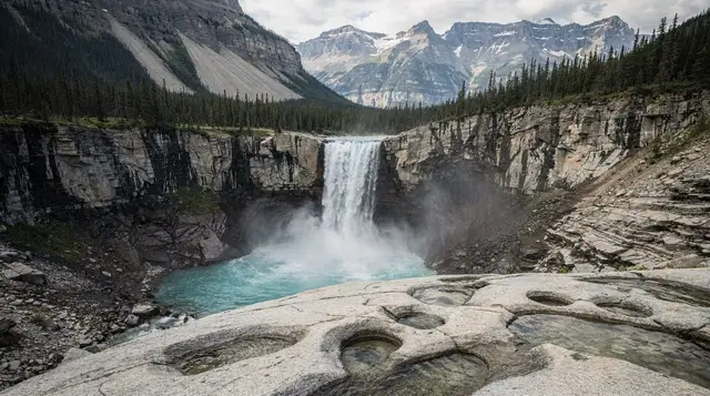
Driven without stopping, the parkway takes about 3 hours 30 minutes. Almost nobody drives it that way. Between glacier-fed lakes, waterfalls, and pullouts with views of hanging glaciers, most visitors turn a 3.5-hour drive into a full day, and some spread it across two. This guide covers the drive as a whole — what to expect, what to plan around, and what can go wrong if you don’t. For the stop-by-stop rundown of what’s actually at each pullout, see our stops in order guide; for help deciding how much time to give it, see one day versus two days.
The parkway is entirely within national park boundaries for its whole length, which matters for two practical reasons covered below: you need a park pass to be on it at all, and services along the way are limited by design, not oversight. Parks Canada keeps development on this corridor deliberately sparse.
The Parks Canada pass, checked even if you don’t stop
Every vehicle on the Icefields Parkway needs a valid Parks Canada pass, full stop. This isn’t a toll for using the viewpoints — it’s an entry fee for being inside Banff and Jasper national parks, and the parkway runs through both for its entire length. A day pass runs roughly 11 CAD per adult, or about 22 CAD per vehicle, with prices set by Parks Canada and worth checking against the current year’s official rate. Anyone planning more than a handful of days in the mountain parks over a year typically comes out ahead with the annual Discovery Pass, around 75 CAD per adult or 150 CAD per vehicle.
The pass requirement catches out a specific kind of traveller: someone driving straight through from Banff to Jasper, or vice versa, with no plan to stop at all. It doesn’t matter. You’re still inside the park boundary for over 200 kilometres, and park wardens do check, particularly at the more popular pullouts like Bow Summit and Peyto Lake. Display the pass on your dashboard before you set out, not after you’ve already parked at the first viewpoint.
One pass covers the whole route. You do not need a separate permit for Kananaskis or any other Alberta provincial land here — the parkway itself never leaves federal park land, so the Parks Canada pass is the only one that applies to this specific drive.
Bow Summit: the highest point on the drive
The parkway’s high point is Bow Summit, at 2,088 metres, sitting roughly at the midpoint between Lake Louise and the Columbia Icefield. It’s the highest paved point on the entire route, and the air noticeably thins and cools compared to the valley floor at Lake Louise, 1,750 metres below. Snow can linger at Bow Summit well into early summer, and the exposed parking area catches wind even on days that felt calm lower down — bring a layer regardless of season.
Bow Summit matters for one specific reason beyond elevation: it’s the access point for the short walk up to the Peyto Lake viewpoint, the platform overlooking one of the most photographed lakes on the parkway. The lake itself sits well below the summit, its intense blue coming from suspended glacial rock flour rather than anything in the water itself — the same phenomenon behind why the Rockies’ lakes turn turquoise. We cover the viewpoint itself, the short paved trail, and the crowd patterns in a dedicated Peyto Lake guide; this page is about the summit as a waypoint on the larger drive, not the walk in detail.
Past Bow Summit, the road descends gradually toward Bow Lake and the base of Crowfoot Glacier before climbing again toward Saskatchewan River Crossing and, eventually, the Columbia Icefield itself — a stop significant enough that it has its own dedicated guide rather than a section here.
No gas after Saskatchewan River Crossing
This is the single most important practical fact about the parkway, and it catches people out every season: there is no year-round fuel between Lake Louise and Jasper. The only station along the entire 232-kilometre route sits at Saskatchewan River Crossing, roughly the halfway point, and it operates seasonally — typically open from spring through fall, closed in winter, and subject to reduced hours even within its open season. There is no guarantee it will be open, staffed, or even operating its pumps when you pass through, particularly early or late in the shoulder seasons.
Fill your tank completely before leaving Lake Louise if you’re heading north, or before leaving Jasper if you’re heading south. Don’t treat Saskatchewan River Crossing as a backup — treat the full tank as the only plan, and the station as a bonus if it happens to be open. Running low on this stretch means limping toward whichever end is closer, with no towing service materializing quickly on a road this remote. For more on this and related logistics, see our gas and cell coverage guide.
Food service follows the same pattern: a lodge and small restaurant at Saskatchewan River Crossing, seasonal like the gas station, and a café at the Columbia Icefield Discovery Centre, open roughly April or May through October. Outside those two points, don’t expect anywhere to buy a meal. Pack food and water for the day.
Cell coverage: patchy, not absent, don’t rely on it
Mobile signal along the Icefields Parkway ranges from weak to nonexistent for most of the drive. Coverage exists in short bursts near Lake Louise, near Saskatchewan River Crossing, and near the Columbia Icefield Discovery Centre — pockets tied to fixed infrastructure — but the long stretches between them run through valleys with no signal at all, often for 30 minutes or more of driving. This isn’t a “check before you go” caveat; it’s a planning constraint.
Download offline maps for the whole route before you leave cell range at either end. Don’t count on real-time traffic alerts, weather updates, or the ability to call for help partway through. If you break down or have an emergency between the pockets of signal, you may need to wait for a passing vehicle or drive to the nearest point with coverage. Tell someone your route and expected arrival time before setting out, the same advice that applies to any drive through remote terrain.
Weather and snow: possible in any month
Because so much of the parkway sits above 1,500 metres, with Bow Summit over 2,000, it experiences mountain weather rather than valley weather. Snow is possible at these elevations in any month of the year, including the middle of summer. It’s uncommon in July and August, but a cold front pushing through can drop a few centimetres at the higher points even then, usually melting off within a day. Spring and fall carry a real chance of snow affecting the road itself, and winter travel is its own undertaking, covered separately in our Icefields Parkway in winter guide.
Check the Parks Canada road report before setting out, particularly outside the July-to-September window. The parkway can see temporary closures for avalanche control, especially near the Sunwapta area, and conditions can shift within a single day at elevation even when the forecast for Lake Louise or Jasper townsite looks mild. Winter tires are legally required on nearby British Columbia routes from October 1 to April 30; the parkway itself sits in Alberta, but carrying winter tires through the shoulder seasons is a sound idea regardless.
Wildlife and driving pace
The parkway passes through some of the least disturbed wildlife habitat in the Rockies, and animals cross the road, sometimes without warning. Bears, both grizzly and black, elk, and mountain goats are all seen here with some regularity. Keep to a sensible speed even where the limit allows more, particularly at dawn, dusk, and through forested sections with limited sightlines. Slowing for a bear or an elk on the shoulder is common enough to expect, not to treat as a rare event.
What this drive is not
A few things worth ruling out before you plan around this page. This guide covers the parkway as a corridor — the pass, the gaps in services, the elevation, and the general shape of the drive. It does not walk through each individual stop in sequence; that’s the job of our stops in order guide, which lists Herbert Lake, Crowfoot Glacier, Bow Lake, Bow Summit and Peyto Lake, Mistaya Canyon, Saskatchewan River Crossing, the Weeping Wall, Sunwapta Pass, the Columbia Icefield, Tangle Creek, Sunwapta Falls, and Athabasca Falls in the order you’ll reach them driving north.
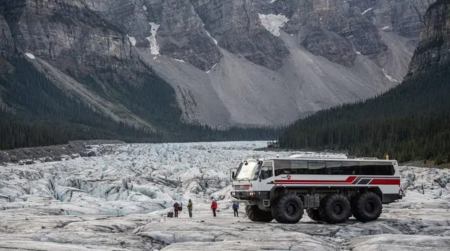
It also doesn’t cover the Columbia Icefield itself in depth — the Ice Explorer vehicles, the Glacier Skywalk, and what each costs — since that stop is significant enough to warrant its own page, linked above. And it doesn’t settle the question of one day versus an overnight break at Saskatchewan River Crossing or in Jasper; that trade-off, with its own costs and benefits, has a dedicated comparison as well.
Table: parkway drive at a glance
| Detail | Figure |
|---|---|
| Total distance | 232 km, Lake Louise to Jasper |
| Drive time, no stops | About 3 h 30 min |
| Drive time, with stops | Typically a full day |
| Highest point | Bow Summit, 2,088 m |
| Gas stations on route | 1, Saskatchewan River Crossing, seasonal |
| Cell coverage | Patchy to none for most of the route |
| Park pass required | Yes, for the entire length |
| Open season for services | Roughly April/May to October |
Booking a guided run of the parkway
Driving the parkway yourself means total control over pacing, but it also means someone in the vehicle is watching the road instead of the glaciers, and it rules out a drink with dinner if you’re doing an evening version of the drive. A guided tour removes both problems and typically adds commentary on the geology and history you’d otherwise miss at 90 km/h.
For a full-day run from the Banff area with stops built in, the Icefields Parkway tour from Calgary covers the drive without you touching the wheel. Travellers who want the Columbia Icefield and the Glacier Skywalk folded into the same day should look at the premium guided tour that bundles the glaciers and the skywalk, which saves arranging separate tickets and transport. Small groups wanting a less bus-like pace can book the small-group Columbia Icefield day tour instead.
If your trip runs the other direction — ending in Banff rather than starting there — the Jasper-to-Banff Columbia Icefields tour covers the same road southbound, useful for anyone doing a one-way loop through Jasper National Park and Yoho before returning toward Calgary.
Getting to the start of the parkway
Both ends of the Icefields Parkway assume you’ve already reached Banff or Jasper. From Calgary and the Calgary airport, it’s about 128 kilometres and 1 hour 30 minutes to Banff, from which Lake Louise, the parkway’s southern start, is another 58 kilometres. There’s no train service to either end — no passenger rail runs this corridor for ordinary travellers, and the closest thing, the Rocky Mountaineer, is a scenic luxury product rather than transport. Renting a car or booking a guided tour are the two realistic options for actually driving the route.
For a wider look at how the parkway fits into a longer Rockies trip, our four-day Banff, Jasper, and Icefields itinerary sequences the drive against overnight stops in both towns, and the icefields parkway road trip itinerary focuses specifically on this stretch of road.
Frequently asked questions about driving the Icefields Parkway
Do you need a park pass just to drive the Icefields Parkway?
Yes, even if you never leave the vehicle. The entire route runs through Banff and Jasper national parks, and a valid Parks Canada day pass or annual Discovery Pass is required for anyone in the vehicle, checked at highway pullouts and viewpoints. Passing straight through without stopping doesn’t exempt you.
Where is the highest point on the Icefields Parkway?
Bow Summit, at 2,088 metres, roughly the halfway point between Lake Louise and the Columbia Icefield. It’s also where the short walk to the Peyto Lake viewpoint starts, making it the one high point on the drive most people actually get out of the car for.
Is there gas along the Icefields Parkway?
Only at Saskatchewan River Crossing, roughly the midpoint of the drive, and that station is seasonal, closed for stretches of the year. Outside of it, there is no fuel between Lake Louise and Jasper, a gap of well over 200 kilometres. Fill up before you leave and don’t assume a station will be open when you arrive.
Does cell phone coverage work on the Icefields Parkway?
Barely, and not reliably. Coverage is patchy at best for most of the route and drops out completely through long sections, particularly the middle stretch away from the highway crossing. Download offline maps and tell someone your plan before you set out.
Can you drive the Icefields Parkway in one day?
Yes, and most visitors do, though it means choosing which stops to linger at rather than seeing everything. Our dedicated comparison of one day versus two days on the parkway breaks down what each pace actually allows.
Is snow possible on the Icefields Parkway in summer?
Yes. Much of the route sits above 1,500 metres, with Bow Summit over 2,000 metres, and snow showers or a light accumulation are possible at that elevation in any month, including July and August. It rarely closes the road in summer, but it does happen.
Is the Icefields Parkway the same road as the route to Moraine Lake?
No. The Icefields Parkway is Highway 93 North, starting near Lake Louise Village and heading north to Jasper. The road to Moraine Lake is a separate, much shorter spur that branches off before you’d ever reach the parkway proper, and it has its own vehicle restrictions.
Columbia Icefield & glacier tours on GetYourGuide
Verified deep-linked GetYourGuide tours. Book through these links and we earn a small commission at no cost to you.
GetYourGuide does not provide a product photo for this activity — the image shows the meeting point, photographed by us.