The Icefields Parkway: a 2-day road trip guide
What the drive time doesn’t tell you
The Icefields Parkway — Highway 93 North between Lake Louise and Jasper — covers 232 kilometres, and every map and GPS will tell you the same thing: 3 hours and 30 minutes, non-stop. That number is accurate and almost useless. Nobody who has come this far is driving past Peyto Lake without pulling over, and nobody should. The real planning number is a full day if you want the viewpoints, and two days if you are adding time at the Columbia Icefield, where the Ice Explorer and Glacier Skywalk each run 1.5 to 3 hours on their own.
This guide treats the parkway as the destination, not a connector between Banff and Jasper. It goes stop by stop, in driving order, with what each one actually takes and what to skip if you are short on time.
The one mistake this itinerary exists to prevent
Do not try to drive the parkway, see the Columbia Icefield, and reach Jasper for dinner in the same afternoon you left Lake Louise. It does not fit. The drive alone is 3.5 hours; add 45 minutes at Bow Summit and Peyto Lake, 20 minutes at Mistaya Canyon, and 2 to 3 hours at the icefield if you book either the Ice Explorer or the Skywalk, and you are at 7 to 8 hours of actual elapsed time before you have eaten lunch or reached Athabasca Falls, which is still 100 kilometres short of Jasper. Give this a full day minimum, two if the icefield is on your list, and start early — the Columbia Icefield’s parking lot and shuttle queues back up by midday in July and August.
Before you leave: what to have sorted
Fuel. There is exactly one gas station on this route, at Saskatchewan River Crossing, roughly the midpoint, and it is seasonal — closed outside the main season. There is no fuel for the 130 kilometres from there to Jasper, and none for the stretch from Lake Louise to Saskatchewan River Crossing either. Fill the tank in Lake Louise or Banff before you start; do not count on topping up along the way.
Cell coverage. Expect little to none for most of the drive. A weak signal appears near Lake Louise, occasionally near Saskatchewan River Crossing, and again close to the Columbia Icefield visitor centre — that’s about it. Download offline maps before you leave cell range, and do not rely on a phone to book a shuttle spot or check opening hours once you’re on the road.
Your park pass. The entire route runs inside Banff National Park and Jasper National Park, and the Parks Canada pass is required for everyone inside the park boundary — including a straight pass-through with zero stops. Buy it in advance online or at a park gate; the self-serve machines at unstaffed entrances don’t always have change.
Seasonal closures. The Columbia Icefield’s visitor attractions — the Ice Explorer glacier tours and the Glacier Skywalk — run roughly April or May through October, weather permitting, and shut down for winter. The parkway itself stays open (weather and avalanche control allowing), but plan around the icefield’s season if that stop matters to your trip.
Day 1: Lake Louise to the Columbia Icefield
Start early — 8 a.m. or before in peak season buys you calmer viewpoints and a shorter queue at the icefield later.
Crowfoot Glacier (about 33 km from Lake Louise)
The first real stop, and an easy one: a roadside pullout with a clear view across the valley to the Crowfoot Glacier, named for the three “toes” its ice once formed. The lowest toe has largely melted away over the past century, which makes it a useful preview of the retreat you’ll see at a much larger scale later in the day. Five to ten minutes is enough unless you want to set up a longer photo.
Bow Lake (about 36 km)
A minute or two past Crowfoot Glacier, Bow Lake opens up on the left, with Bow Glacier and the Wapta Icefield behind it and the historic Num-Ti-Jah Lodge on the near shore. It’s a quieter, less crowded lake than Louise or Moraine, worth 15 to 20 minutes for the shoreline walk and photos.
Bow Summit and Peyto Lake (about 40 km)
Bow Summit, at 2,088 metres, is the highest point on the parkway and the turnoff for Peyto Lake, the most photographed viewpoint on this route — a wolf-shaped, intensely turquoise lake seen from a boardwalk above the treeline. The upper viewing platform is a short, paved 10-minute walk from the parking lot; a longer trail continues to a quieter lower viewpoint if you have another 30 minutes. This is also the stop most likely to have a bus-tour crowd, so arriving before 10 a.m. or after 4 p.m. makes a real difference.
Mistaya Canyon (about 71 km)
A short, moderately steep 20-minute round-trip walk down to a limestone canyon carved by meltwater, with a natural bridge crossing near the bottom. Mistaya Canyon gets a fraction of the traffic of Johnston Canyon back near Banff and is worth the detour if you have 25 to 30 minutes to spare.
Saskatchewan River Crossing (about 77 km)
The approximate midpoint of the drive, and the only fuel and services stop on the entire route — seasonal, so check ahead if you’re travelling in shoulder season or winter. A short break here (washrooms, coffee, a stretch) makes sense before the second half of the drive, which climbs toward the Columbia Icefield.
The Columbia Icefield (about 127 km)
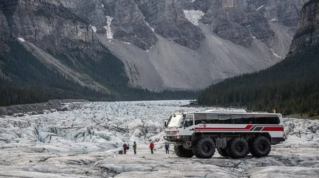
This is the anchor of the trip, and where the “half a day” plan falls apart. The Columbia Icefield feeds the Athabasca Glacier, which is retreating by roughly 5 metres a year — visibly shorter than it was even a decade ago, marked by roadside posts showing where the ice front used to sit.
Two paid attractions run from the same visitor centre, bookable together or separately:
| Attraction | What it is | Approximate time |
|---|---|---|
| Ice Explorer glacier tour | Guided ride onto the Athabasca Glacier in a giant-wheeled bus, with time to walk on the ice | 1.5–2 hours |
| Glacier Skywalk | Glass-floored platform 280 metres above the Sunwapta Valley | 45 minutes–1 hour, including the shuttle |
Both require advance booking in peak season and only operate roughly April/May through October. If you’re combining both, allow 2.5 to 3 hours at this stop alone — another reason the “one big day” version of this drive doesn’t work.
a day tour from Calgary that covers the Skywalk plus Peyto and Bow lakes in one booking is a reasonable option if you’d rather not self-drive the whole route, and it removes the parking and shuttle-queue guesswork at the icefield itself.
Overnight
Stop here for the night — either backtrack to Lake Louise/Banff if you’re doing a there-and-back trip, or press on roughly 105 km to Jasper for the night, picking up the last stretch of stops the next morning. Jasper has the wider range of accommodation and is the better base if you’re continuing north.
Day 2: The Columbia Icefield to Jasper
The final stretch is shorter — about 105 kilometres — but has two worthwhile waterfall stops before town.
Tangle Creek and Sunwapta Falls (about 55 km from the icefield)
A compact, easily accessed set of falls where the Sunwapta River drops through a canyon in a sharp bend. A paved viewpoint is a two-minute walk from the parking lot; a longer trail to the lower falls adds 30 to 40 minutes round trip if you have the time.
Athabasca Falls (about 87 km)
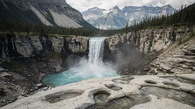
Smaller in height than Sunwapta but more powerful in volume, Athabasca Falls drops through a narrow limestone gorge and is one of the most-visited stops on the whole parkway for good reason — it’s dramatic and it’s a 10-minute walk from the car. Budget 20 to 30 minutes.
Into Jasper (about 105 km)
The parkway ends at the Yellowhead Highway junction just outside town. Jasper itself — the largest national park in the Canadian Rockies at roughly 11,000 square kilometres — rebuilt after the July 2024 wildfire destroyed about a third of its townsite buildings, and it’s open again to visitors, though some trails and areas nearby still show the aftermath. Worth knowing rather than avoiding.
If you have another half-day here, the Jasper SkyTram climbs to 2,263 metres — the highest guided aerial tramway in Canada — and a Jasper-based tour back to the Skywalk is a workable option if you’d rather see the icefield attractions on the way north instead of the way south.
Planning it the other way: guided instead of self-drive
Not everyone wants to manage fuel stops, shuttle bookings, and a return drive alone. A guided option handles the logistics and usually includes a Calgary or Banff pickup:
- a full-day tour covering Bow Lake, Peyto Lake, and the icefield, useful if you want the stops without renting a car at all.
- A similar option adds Crowfoot Glacier to the same rough itinerary, for travellers who want that stop covered too.
These tend to run 10 to 12 hours from Banff or Calgary and back, which tells you something useful on its own: even a guided day trip treats this as a full day, not a quick detour.
How this compares to other ways through
If you’re deciding whether to build a dedicated Icefields Parkway trip or fold it into a bigger loop, a few comparisons help:
- The complete stop-by-stop reference for this route covers every named viewpoint in order, useful if you want more detail than a 2-day framework.
- The question of one day versus two on the parkway goes deeper into what each version actually skips.
- If you’re heading back through Yoho or Kootenay afterward, our five-day Banff, Yoho, and Kootenay itinerary and six-day full loop both fold this drive into a longer route.
- Driving it in winter is a different trip entirely — the parkway’s snow-season conditions and closures deserve their own read before assuming this itinerary applies year-round.
Icefields Parkway two-day itinerary at a glance
| Day | Route | Key stops | Approximate driving |
|---|---|---|---|
| Day 1 | Lake Louise to Columbia Icefield | Crowfoot Glacier, Bow Lake, Peyto Lake, Mistaya Canyon, Saskatchewan River Crossing | ~127 km, 2–2.5 hrs driving, full day with stops |
| Day 2 | Columbia Icefield to Jasper | Sunwapta Falls, Athabasca Falls | ~105 km, 1.5 hrs driving, half day with stops |
Frequently asked questions about driving the Icefields Parkway
How long does the Icefields Parkway actually take to drive?
Non-stop, 3 hours and 30 minutes covers the 232 kilometres from Lake Louise to Jasper. But nobody drives it non-stop: with photo stops at Crowfoot Glacier, Bow Lake, Peyto Lake, and Mistaya Canyon, plan on a full day. Add the Columbia Icefield’s Ice Explorer or Glacier Skywalk and it becomes a two-day trip with an overnight in Jasper or back in Banff.
Can I drive the Icefields Parkway in half a day?
Not properly. A half-day gets you to Bow Summit and back with a rushed look at two or three viewpoints, but you will miss the Columbia Icefield entirely and arrive in Jasper without having stopped at Athabasca Falls or Sunwapta Falls. Treat this as a full-day drive at minimum.
Is there gas along the Icefields Parkway?
One station, at Saskatchewan River Crossing, roughly the midpoint, and it is seasonal — closed in winter and shoulder season. There is no fuel between there and Jasper, about 130 kilometres, and none between Lake Louise and Saskatchewan River Crossing either. Fill up in Lake Louise or Banff before you start.
Do I need a Parks Canada pass just to drive through?
Yes. The Icefields Parkway runs entirely inside Banff and Jasper national parks, and the pass is required for anyone in the park, including a straight pass-through with no stops. Buy it before you go, at a park gate, or online, since staffed booths are not always open.
When is the Columbia Icefield open?
The Ice Explorer glacier tours and the Glacier Skywalk typically run from April or May to October, weather dependent, and close for the winter. Check the current season before building a trip around them, since an off-season visit means the parkway itself stays open but the icefield attractions do not.
Is there cell service on the Icefields Parkway?
Barely. Coverage is patchy to non-existent for most of the 232 kilometres, with brief signal near Lake Louise, around Saskatchewan River Crossing, and near the Columbia Icefield visitor centre. Download offline maps and tell someone your route before you leave, the same as any remote highway drive.
Can I do the Icefields Parkway as a day trip from Banff and back?
Yes, if you turn around after the Columbia Icefield rather than continuing to Jasper, which turns the trip into roughly 460 kilometres round trip and a very long day. Most travellers do better sleeping one night in Jasper and returning the next day, or continuing the loop toward Yoho and Kootenay.
Columbia Icefield & glacier tours on GetYourGuide
Verified deep-linked GetYourGuide tours. Book through these links and we earn a small commission at no cost to you.
GetYourGuide does not provide a product photo for this activity — the image shows the meeting point, photographed by us.