Icefields Parkway stops in order: Lake Louise to Jasper
What order do the Icefields Parkway stops come in?
Driving north from Lake Louise: Herbert Lake, Crowfoot Glacier, Bow Lake, Bow Summit and Peyto Lake, Mistaya Canyon, Saskatchewan River Crossing, the Weeping Wall, the Columbia Icefield, Tangle Creek, Sunwapta Falls, and Athabasca Falls before Jasper. The full drive covers 232 kilometres and takes about 3.5 hours without stops.
The Icefields Parkway doesn’t have a secret order — the stops run in a fixed line along Highway 93 North, and the only real decision is how much time you give each one. This is that line, in the order you’ll actually meet it driving from Lake Louise to Jasper, with the approximate distance or drive time from the previous stop so you can budget a day that doesn’t leave you rushing the last hour in the dark.
Treat every distance here as a rough figure, not a number to check against your odometer. Road construction, wildlife closures, and the exact spot you parked all shift things by a kilometre or two. What doesn’t shift is the sequence.
Before you start: Lake Louise to the parkway junction
The Icefields Parkway officially begins at the junction with the Trans-Canada Highway, a few minutes north of Lake Louise village. From here it’s 232 kilometres to Jasper, and roughly 3.5 hours of driving if you never got out of the car — which nobody does. Fill your tank in Lake Louise or Banff before you leave; there is no year-round fuel again until Jasper, with one seasonal exception partway along.
If you haven’t already, this is also the point to make sure your Parks Canada pass is sorted, since the entire route runs through Banff National Park and then Jasper National Park.
Herbert Lake — the warm-up stop
About 5 to 10 minutes north of the junction. Herbert Lake is a small, easy-to-miss pond right off the highway, with Mount Temple reflected in the water on a still morning. There’s a short pullout and a two-minute walk to the shore. It’s not a destination in its own right, but if you’re already slowing down for the first few kilometres of the drive, it costs almost nothing to stop. Best light is early morning, before wind breaks up the reflection.
Crowfoot Glacier viewpoint — a two-minute look
Roughly 25 to 30 minutes past Herbert Lake. A roadside pullout gives a distant view of Crowfoot Glacier, named for the three “toes” of ice that used to hang off the ridge — one has since melted away, leaving two. There’s an interpretive sign and nowhere to walk beyond the parking area itself. This is a look-and-go stop: budget five minutes, not fifty. The detailed picture of what you’re seeing and why the glacier has changed shape belongs on its own Crowfoot Glacier page — here it’s simply the marker that tells you Bow Lake is next.
Bow Lake — the easy lake stop
A few minutes further, same general stretch as Crowfoot Glacier. Bow Lake is one of the few glacial lakes on this drive that needs no shuttle and no reservation — just a parking area right off the highway and a short walk to the shore. Num-Ti-Jah Lodge sits on the far bank and has a seasonal café if you need a coffee. This is a good place to actually get out of the car for fifteen or twenty minutes rather than snap a photo through the windshield. The full case for lingering here is in the Bow Lake and Crowfoot Glacier guide.
Bow Summit and Peyto Lake — the high point of the drive
About 10 to 15 minutes north of Bow Lake. The road climbs to Bow Summit, at 2,088 metres the highest point on the parkway, and from the parking area a paved path leads to the overlook above Peyto Lake. This is one of the two or three stops people build the whole day around, and for good reason — the lake’s colour and the wolf-shaped shoreline are genuinely striking once the glacial meltwater season has turned the water turquoise, typically from mid-June onward. Budget 30 to 45 minutes, more if you want to walk further along the ridge trail. Parking fills fast here in summer; arriving before 10 a.m. or after 4 p.m. avoids the worst of it.
Mistaya Canyon — a short walk off the road
Roughly 20 to 25 minutes north of Bow Summit. A short, forested trail — about 15 minutes each way — drops down to a narrow limestone canyon where the Mistaya River has carved smooth, twisting channels. There’s a footbridge over the gorge. It’s a modest stop, easy to fold into a day without much cost, but also one of the easiest to skip if you’re running behind schedule.
Saskatchewan River Crossing — the halfway mark
About 15 to 20 minutes past Mistaya Canyon. This is roughly the midpoint of the drive and the one place with services along the entire route — a seasonal gas station, a café, and a small lodge. It’s worth treating this as your planned bathroom-and-fuel stop rather than hoping something turns up later, because nothing does until Jasper. Hours are seasonal and can be limited outside peak summer months, so don’t count on it being open late in the day or outside the summer season.
The Weeping Wall — slow down, don’t linger
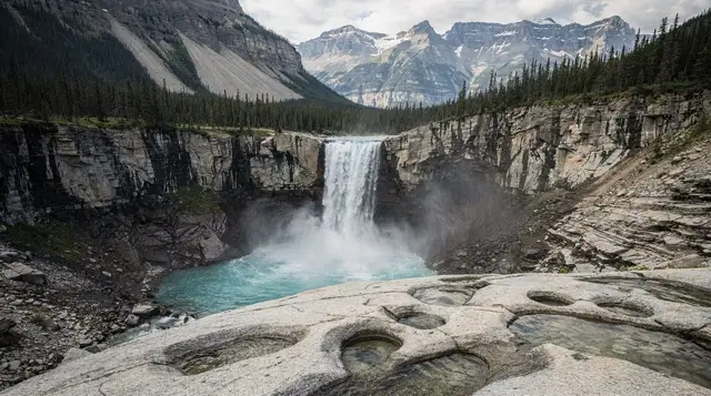
About 10 minutes north of Saskatchewan River Crossing. A limestone cliff face where dozens of small waterfalls and seeps trickle (or, in winter, freeze into ice climbing routes) down the rock. The pullout here is narrow and sits close to the traffic lane, with cars moving at highway speed just a few metres away. It’s a fine stop to slow down and glance at through the window, or step out briefly for a photo from the shoulder — it is not a place to wander along the road on foot or cross to the other side for a better angle. Treat it as a 2-minute look, not a destination.
Bow Summit’s climb continues: the approach to the icefield
Roughly 30 to 40 minutes north of the Weeping Wall. The highway climbs again through the Sunwapta Pass area toward the Columbia Icefield, crossing from Banff National Park into Jasper National Park along the way. There’s no single named stop through here — it’s simply the drive that sets up the next major one.
The Columbia Icefield — the anchor of the day
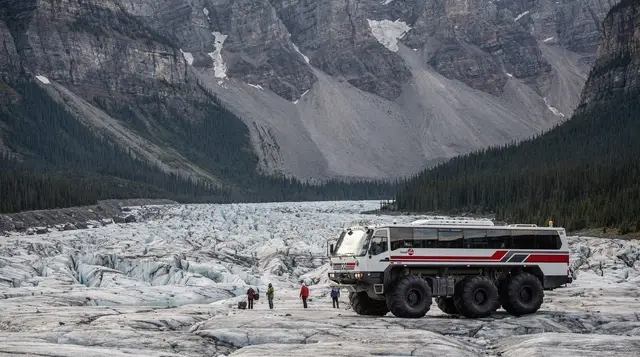
You’ll reach the Columbia Icefield Discovery Centre roughly 20 to 30 minutes after the Weeping Wall climb. This is the one stop most people build their whole Icefields Parkway day around, and it deserves more time than any other point on the drive — an hour at minimum, two or three if you’re booked onto the Ice Explorer glacier tour or the Glacier Skywalk. Both operate seasonally, roughly April or May through October, and both are worth booking ahead in peak summer.
Because this stop has its own detailed guide, the practical logistics — tickets, timing, what the Ice Explorer actually involves — live on the Columbia Icefield guide rather than here. For this list, what matters is where it sits: roughly two-thirds of the way from Lake Louise to Jasper, and the point where most day-trip itineraries spend the bulk of their time.
a Calgary-based day tour that covers the Icefields Parkway and pairs it with the Skywalk handles the whole stretch from Lake Louise to the icefield in one guided trip, which is worth considering if you’d rather not manage the driving and the timed-entry bookings yourself.
Tangle Creek and Tangle Falls — a quick roadside look
A few minutes north of the Discovery Centre. A small, multi-tiered waterfall visible right from the highway shoulder, with a pullout for a quick photo. It doesn’t need more than five or ten minutes, and many people driving straight through barely register it — but if you’ve already stopped for the icefield, it’s an easy add-on on the way out.
Sunwapta Falls — the detour off the highway
About 40 to 50 minutes north of the Columbia Icefield. A short side road (a few minutes’ drive) leads to Sunwapta Falls, where the Sunwapta River drops through a sharp canyon bend. The main viewpoint is close to the parking area, a couple of minutes’ walk, with a longer trail available if you want to see the lower falls as well. Budget 20 to 30 minutes for the main viewpoint alone.
Athabasca Falls — the last major stop before Jasper
Roughly 20 minutes north of Sunwapta Falls, and about 30 minutes south of Jasper townsite. Athabasca Falls isn’t the tallest waterfall on this drive, but it’s arguably the most powerful, forcing the full volume of the Athabasca River through a narrow quartzite gorge. Paved paths and viewing platforms make it one of the more accessible stops on the whole route, and it’s worth 20 to 30 minutes even late in the day, since it’s close enough to Jasper that it’s an easy last stop before checking into town.
Into Jasper
From Athabasca Falls, it’s a straightforward final stretch into Jasper — about 30 minutes with no more named stops along the way. If you’re continuing on to the Jasper SkyTram or Maligne Canyon the same day, note that both sit on the far side of town from where you’ll arrive, adding time to an already long day.
The stops in order, at a glance
| Stop | Approx. time from previous stop | What it needs |
|---|---|---|
| Herbert Lake | Start of the parkway | 5-minute walk |
| Crowfoot Glacier viewpoint | ~25-30 min | Roadside look, 5 min |
| Bow Lake | A few minutes further | 15-20 min walk |
| Bow Summit / Peyto Lake | ~10-15 min | 30-45 min, paved path |
| Mistaya Canyon | ~20-25 min | 15 min walk each way |
| Saskatchewan River Crossing | ~15-20 min | Fuel, food, washrooms |
| The Weeping Wall | ~10 min | Roadside only, 2 min |
| Columbia Icefield | ~50-70 min | 1-3+ hours |
| Tangle Creek/Falls | A few minutes further | 5-10 min |
| Sunwapta Falls | ~40-50 min | 20-30 min, short side road |
| Athabasca Falls | ~20 min | 20-30 min, paved paths |
| Jasper townsite | ~30 min | End of drive |
Planning the rest of the day
If you’re trying to decide whether all of this fits into a single day or is better split over two, the one day versus two days breakdown walks through the trade-offs. For the wider context on what each named stop actually looks like once you’re standing at it, the complete Icefields Parkway guide is the companion piece to this one. And if fuel and cell coverage are what’s worrying you most, that’s covered in detail separately in a guide on gas and cell coverage along the parkway.
A few tours run this exact route so you don’t have to manage the driving, the timed icefield tickets, and the daylight budget all at once. a full-day Icefields Parkway tour departing from Calgary covers the drive from Lake Louise through to the Columbia Icefield and back, and a one-way Jasper-to-Banff tour along the same route is worth considering if you’re overnighting in Jasper anyway and don’t want to backtrack by car.
For those based in Banff or Canmore who want the drive without renting a car, a guided day trip picking up from Canmore or Banff follows the same order of stops described above.
Frequently asked questions about the Icefields Parkway stop order
What order are the Icefields Parkway stops in from Lake Louise to Jasper?
Driving north on Highway 93: Herbert Lake, the Crowfoot Glacier viewpoint, Bow Lake, Bow Summit and Peyto Lake, Mistaya Canyon, Saskatchewan River Crossing, the Weeping Wall, the Columbia Icefield, Tangle Creek, Sunwapta Falls, and finally Athabasca Falls before you reach Jasper.
How long does the Icefields Parkway take with stops?
The 232-kilometre drive takes about 3.5 hours non-stop, but plan on a full day, roughly 7 to 9 hours, if you want to get out at most of the named stops, walk to a few viewpoints, and spend an hour or two at the Columbia Icefield.
Can I do the Icefields Parkway in one day round trip from Banff or Lake Louise?
Yes, but it’s a long day: Lake Louise to Jasper and back is roughly 460 kilometres of driving alone. Most visitors either stay a night in Jasper, or accept that a round trip leaves less time at each stop, especially if the Columbia Icefield glacier tour or Skywalk is on the list.
Is there gas or food along the Icefields Parkway?
There is no year-round fuel between Lake Louise and Jasper. Saskatchewan River Crossing has a seasonal gas station and a café, roughly the midpoint, and the Columbia Icefield Discovery Centre has a seasonal café as well. Fill up before you leave Lake Louise or Jasper regardless.
Is the Weeping Wall safe to stop at?
The pullout is small and sits close to the travel lane, with fast-moving highway traffic. It’s fine to slow down, glance over, and take a photo from the shoulder, but it’s not a spot to linger on foot, and it’s not worth backing up or crossing the road for a better angle.
Do I need a Parks Canada pass just to drive through on the Icefields Parkway?
Yes. The road runs entirely inside Banff and Jasper national parks, so a valid Parks Canada pass is required even if you don’t plan to stop, roughly 11 CAD per adult per day or about 22 CAD per vehicle, with an annual Discovery Pass an option if you’re visiting multiple parks.
Does cell phone coverage work along the drive?
Coverage is patchy to non-existent for long stretches, particularly between Saskatchewan River Crossing and the Columbia Icefield. Download offline maps and let anyone expecting to hear from you know you’ll be out of range for a few hours.
Which stops should I skip if I’m short on time?
Herbert Lake and Mistaya Canyon are the easiest to cut if you’re behind schedule — both are quick add-ons rather than must-sees. Bow Lake, Peyto Lake, and the Columbia Icefield are the three most people regret skipping.
Columbia Icefield & glacier tours on GetYourGuide
Verified deep-linked GetYourGuide tours. Book through these links and we earn a small commission at no cost to you.
GetYourGuide does not provide a product photo for this activity — the image shows the meeting point, photographed by us.