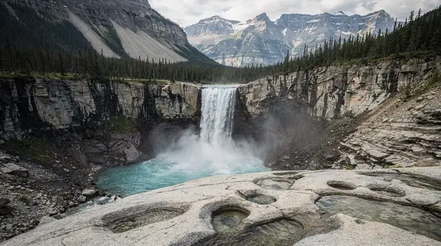
Athabasca Falls doesn’t look like much on a map. A drop of only around 20 metres barely registers next to the Columbia Icefield or the mountains stacked up along the drive to Jasper, and a first-time visitor scanning the numbers before arriving could be forgiven for planning a five-minute glance and moving on. Then you actually stand at the railing, and the modest height stops mattering. What’s in front of you is the entire glacier-fed Athabasca River forced through a slot in solid quartzite barely wider than a hallway, and the result is loud, fast and genuinely startling at close range.
That mismatch between the numbers and the experience is exactly why this page exists. Athabasca Falls rewards very little effort: a short, paved walk from a roadside parking lot gets you to multiple viewpoints and footbridges, with no real hiking involved. That ease of access, combined with its position on one of the busiest stretches of the Icefields Parkway, makes it one of the most frequently visited stops on the entire route between the icefield and Jasper.
A canyon, not a cliff
The falls themselves aren’t the whole story. What makes this site distinctive is the narrow quartzite canyon just downstream, carved by the river over thousands of years as it worked through some of the hardest, most erosion-resistant rock in the region. The channel is barely a few metres across in places, and the river’s full volume gets funnelled through it at speed, undercutting the walls, carving potholes into the bedrock and leaving an abandoned former channel visible off to one side where the river used to run before cutting its current path.
Walking the footbridges that cross both the falls and the canyon lets you see this from several angles: straight down into the churn at the main drop, along the canyon walls where the rock has been polished smooth, and across to the dry, older channel that shows how much the river’s course has shifted over time. None of this requires any particular geological background to appreciate. The shape of the rock alone tells the story of a river that has spent a very long time cutting a very hard obstacle down to size.
For more on how glacial meltwater rivers like the Athabasca behave and why so much of the parkway’s scenery comes down to ice and water working on rock over long timescales, the glaciers retreat, explained guide covers the icefield that feeds this same river system further upstream.
Getting there: parking, paths and how easy it really is
This is the detail that separates Athabasca Falls from most other big-name stops in the Rockies: there’s no hike required to see it properly. A parking lot sits directly beside the highway, at the junction of the Icefields Parkway (Highway 93) and Highway 93A, and the main viewpoint is a short, level, paved walk away from your car. From there, a network of paved paths and footbridges loops around both sides of the falls and along the top of the canyon, with a few short sets of stairs leading down to lower viewpoints for visitors who want a closer angle into the canyon itself.
| What | Details |
|---|---|
| Distance from parking to main viewpoint | A few minutes on a paved, level path |
| Total time on paved loop | 20-45 minutes for most visitors |
| Elevation gain | Minimal on the upper paths; some stairs to lower canyon viewpoints |
| Admission | No separate fee; covered by your Parks Canada park pass |
| Facilities | Washrooms at the parking area; no food service on-site |
Because the access is this easy, the parking lot fills up fast in July and August, particularly between late morning and mid-afternoon when traffic along the parkway peaks. Arriving early in the morning or later in the day, closer to sunset, generally means an easier time finding a spot and a quieter set of viewpoints for photos. If you’re planning fuel stops or expect to need connectivity along this stretch, read the gas and cell coverage along the Icefields Parkway guide before you set out, since there’s no fuel and only patchy coverage for long sections of this drive.
A valid Parks Canada pass is required to be on this stretch of highway at all, whether or not you stop at the falls, since the road runs through Jasper National Park. If you haven’t sorted that out yet, do it before you arrive rather than at the pullout.
Safety: why the railings actually matter here
This is the single most important thing on this page, and it isn’t an exaggeration for effect. The rock surfaces around Athabasca Falls stay damp from constant spray, and that dampness makes them far more slippery than they look, especially close to the canyon edge where the footing narrows and the drop is direct. There have been fatal falls at this exact site among visitors who crossed barriers to get a closer angle or a better photo, and Parks Canada treats the railings here as a hard line, not a suggestion.
A few concrete rules worth following without exception:
- Stay on the marked paths and behind every railing, even when the view looks marginally better a few steps beyond it.
- Keep a firm hold on children near any canyon-edge viewpoint; the drop is close, direct and unguarded past the barriers.
- Never wade, swim or climb down into the canyon itself; the current is far stronger than the width of the channel suggests, and there’s no safe way back out once you’re in it.
- Wet rock near the falls is slippery even where it doesn’t look wet; treat every surface close to the spray zone as if it were.
None of this should stop you from visiting. The viewpoints built into the paved paths give a full, close-up experience of the falls and canyon without needing to go anywhere near the edge unprotected. The risk here comes entirely from visitors choosing to cross barriers, not from the site itself when visited as designed.
Athabasca Falls vs. Sunwapta Falls: don’t mix them up
Athabasca Falls shares more than a passing resemblance with Sunwapta Falls, another waterfall on the same road where a river drops through a narrow rock channel. The two get confused constantly in trip planning, partly because they look similar in photos and partly because they sit on the same drive, so it’s worth being precise about where each one actually is.
| Athabasca Falls | Sunwapta Falls | |
|---|---|---|
| Position on the parkway | Closer to Jasper, about 30 km south of town | Farther south, closer to the Columbia Icefield |
| Rock type | Quartzite canyon | Different channel, similar narrow-gorge profile |
| Access | Roadside parking, paved paths | Covered on its own dedicated page |
| Common mix-up | Assumed to be the same stop as Sunwapta Falls | Assumed to be the same stop as Athabasca Falls |
This page covers Athabasca Falls specifically. For details on Sunwapta Falls itself, its own access and what makes it distinct, see its dedicated page rather than assuming the two are interchangeable stops on the same visit. The Athabasca and Sunwapta Falls guide walks through both side by side if you’re trying to fit them into the same day and want to keep the details straight.
Timing it into an Icefields Parkway day
Athabasca Falls works best as one stop among several rather than a destination in its own right, and its position close to Jasper makes it a natural late-day stop if you’re driving north from the Columbia Icefield, or an early stop if you’re heading south out of Jasper toward Banff. Because it needs so little time, it’s easy to fold into a day that also covers the icefield itself, the surrounding viewpoints, and a stop in Jasper by evening.
If you haven’t mapped the rest of the drive yet, the Icefields Parkway complete guide and the Icefields Parkway stops in order guide both lay out the full sequence of viewpoints between Lake Louise and Jasper, with Athabasca Falls positioned near the northern end close to town. If you’re weighing whether to do the whole drive in one long day or split it over two, the one day versus two days comparison is worth reading before you commit either way, since a stop like this one adds up quickly alongside a dozen others.
Travellers who’d rather not manage the driving and timing themselves can book a guided option that includes this stretch of the route. The day tour that stops at Athabasca Falls alongside Sunwapta Falls and Peyto Lake covers this exact cluster of roadside sights in one outing, which removes the need to plan your own stop order.
For visitors starting from the Banff side who want the falls folded into a fuller Columbia Icefield day, the guided Icefields Parkway tour from Banff that includes the Columbia Icefield glacier handles the long drive and the icefield stop together. If your priority is the icefield itself and a discounted ticket matters more than the falls, the discounted Columbia Icefield admission is worth checking before you book the full-price rate directly.
For a fuller day-by-day plan that works this stretch of the parkway into a longer Rockies trip, the Icefields Parkway road trip itinerary sequences Athabasca Falls alongside the icefield, Peyto Lake and the rest of the drive rather than leaving you to plan the stop order from scratch.
Athabasca Falls in winter
The Icefields Parkway stays open through winter, conditions permitting, and Athabasca Falls is one of the stops that keeps drawing visitors even in the cold months. Parts of the falls and the surrounding rock freeze into thick ice formations, and the canyon takes on a completely different character than its summer version, quieter and starker against the snow. That said, winter visits demand real caution: the paved paths that feel effortless in July turn genuinely icy, and the spray zone near the falls builds up ice on surfaces that don’t always look slippery at a glance.
If you’re planning a winter drive along this stretch, footwear with real traction is worth having before you get out of the car, and the same rule about staying behind railings applies with even less margin for error, since ice removes any grip a misplaced step might otherwise have had on dry rock. The Icefields Parkway in winter guide covers what changes about this drive once the season turns, including which stops (this one included) stay worth the detour and which ones lose most of their appeal without summer water levels.
Jasper, close by
Athabasca Falls sits roughly 30 kilometres south of Jasper townsite, close enough that it’s often the last roadside stop before arriving, or the first one heading out. Jasper itself continues to welcome visitors following the July 2024 wildfire that destroyed roughly a third of the town’s buildings; the community has rebuilt substantially, though some areas and trails still carry visible marks of the fire. If Jasper is your overnight base or your turnaround point on this drive, the Jasper after the 2024 wildfire guide covers what’s changed and what to expect on arrival, honestly rather than glossing over it.
For visitors approaching from the Jasper side rather than from Banff, the same cluster of nearby sights, Sunwapta Falls, Athabasca Falls and the icefield further south, works equally well as a half-day loop before heading back into town, and the Athabasca Falls activity page rounds up other things to do at this same stop if you’re building out a longer visit around it.
Athabasca Falls questions, answered
How tall is Athabasca Falls?
Only around 20 metres, which is modest by Rockies standards and far shorter than what most visitors expect from the noise and spray. The power here comes from volume squeezed through a narrow gap, not from height, so don’t come expecting a long freefall.
Why is Athabasca Falls so powerful if it isn’t very tall?
The Athabasca River, already a substantial glacier-fed flow, gets forced through a narrow slot cut into hard quartzite bedrock. That bottleneck concentrates the entire river’s volume into a much smaller channel, which is what produces the force, the spray and the noise rather than the drop itself.
How much time do I need at Athabasca Falls?
Most visitors are on-site for 20 to 45 minutes, enough time to walk the paved loop, cross the footbridges and take in both the main viewpoint and the canyon below. It’s built as a quick stop, not a destination to plan half a day around on its own.
Is Athabasca Falls stroller and wheelchair accessible?
The main paths and the principal viewpoint, reached directly from the parking lot, are paved and manageable for strollers and most wheelchairs. Some of the lower canyon viewpoints involve short sets of stairs, so not every angle on the falls is step-free; stick to the upper paths if that’s a hard requirement.
Is Athabasca Falls the same as Sunwapta Falls?
No, they’re two different waterfalls on the same stretch of the Icefields Parkway with a similar look on camera. Sunwapta Falls sits farther south, closer to the Columbia Icefield, while Athabasca Falls is closer to Jasper; see the dedicated guide to keep the two straight before you plan stops.
Is it safe to go past the railings for photos?
No. The rock surfaces around the falls stay wet from spray and are far more slippery than they look, and there have been fatal falls at this exact site among visitors who crossed barriers for a closer shot. Stay on the marked paths and behind every railing, no exceptions.
Can I visit Athabasca Falls in winter?
Yes, the Icefields Parkway stays open (conditions permitting) and the falls partially freeze into dramatic ice formations, but the paths and viewpoints get genuinely icy. Footwear with real traction matters more here in winter than at almost any other stop on the parkway.
Where do I park, and is there a fee?
There’s a parking lot right beside the highway at the falls, a short and level walk from the first viewpoint, with no separate admission fee beyond your Parks Canada pass. It fills up during midday in July and August, so early morning or late afternoon visits are easier.