Why the Rockies' glaciers are retreating, explained through Athabasca
How fast is the Athabasca Glacier retreating, and does that rate apply to all the glaciers on the Icefields Parkway?
The Athabasca Glacier, the most visited and best-measured glacier in the Canadian Rockies, currently loses roughly 5 metres of length a year on average, visible as a widening gap between the parking area and the ice front over the decades. That figure is specific to Athabasca; the Columbia Icefield's other outlet glaciers retreat at their own, differently documented rates, depending on elevation, aspect, and how much of the ice is shaded or buried under rock debris.
Reading a glacier like a tape measure
Every glacier along the Icefields Parkway is, in effect, a very slow tape measure, recording decades of climate in the position of its own edge. Nowhere in the Canadian Rockies is that easier to read than at the Athabasca Glacier, the most visited and most closely measured outlet of the Columbia Icefield.
This guide isn’t about how to book the Ice Explorer or the Glacier Skywalk, that’s covered in our Columbia Icefield guide and our Ice Explorer guide. It’s about the phenomenon itself: why the ice is retreating, how fast, and what you can and can’t conclude from that one well-documented glacier about all the others sharing the same icefield.
The headline number is straightforward. The Athabasca Glacier currently loses roughly 5 metres of length a year on average. That’s a long-term average, not a fixed annual rate: some years the loss is smaller, some years larger, depending on how much snow fell in the accumulation zone high on the icefield and how hot and long the previous summer was. Averaged over the decades that Parks Canada and researchers have been tracking it, though, the trend line has moved consistently in one direction.
What “retreat” actually means
Glacial retreat sounds dramatic, but the mechanics are simple bookkeeping. A glacier is a slow river of ice, fed at its top by snow that compresses into ice over years, and drained at its bottom, or toe, by melting and, in a few cases, calving into meltwater lakes. When more snow accumulates at the top than melts away at the bottom in a given year, the glacier’s toe pushes forward, or advances. When the reverse happens, the toe melts back faster than fresh ice arrives to replace it, and the glacier retreats, meaning the visible edge of the ice ends up sitting further up-valley than it did the year before.
Retreat doesn’t require the whole glacier to somehow move backward. Ice still flows downhill the entire time, the same way a river keeps flowing even while a drought lowers its level. What retreats is the position of the toe, the line where the ice finally melts away faster than new ice arrives to hold that ground. Over one season that shift might only be a few metres, easy to miss. Multiplied over a decade, it adds up to tens of metres. Multiplied over the century-plus that Athabasca has been observed, it adds up to a genuinely different landscape than the one early visitors photographed.
Seeing the Athabasca Glacier’s retreat with your own eyes
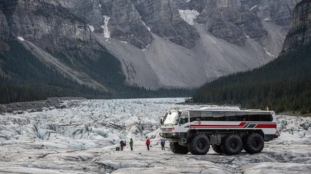
You don’t need scientific instruments to see this one. The walking trail from the current parking area toward the Athabasca Glacier’s toe crosses a landscape of bare rock and rubble, ground the ice itself covered within living memory. Along that trail, Parks Canada has placed a series of dated marker posts, each showing where the glacier’s edge stood in a particular year. Walk from the parking lot toward the ice today and you pass post after post, each one further from the current ice front than the last, a simple, physical record of a hundred-plus years of retreat compressed into a fifteen- or twenty-minute walk.
The parking area itself is part of the evidence. Older maps and photographs show the glacier’s toe reaching much closer to where cars now park than it does today; the distance visitors now have to walk just to reach the ice is itself a measurement, growing year over year as the glacier keeps retreating. None of this requires booking a ticket or joining a tour: the public viewing area near the Columbia Icefield Discovery Centre, free to reach on foot from the parking lot with a valid Parks Canada pass for the parkway itself, is enough to see the pattern.
A short bit of arithmetic makes the scale concrete without overstating it. At roughly 5 metres a year, a decade of retreat moves the ice front back by something on the order of 50 metres. Multiply that across the several decades since organized viewing began at the icefield, and the toe has pulled back by a distance measured in the hundreds of metres, not a few paces. That’s the number worth carrying with you on the walk, not as a precise year-by-year prediction, but as a sense of scale for what a “slow” process looks like once it’s had a century to work.
Why the same number doesn’t apply to the rest of the icefield
Here’s where it’s easy to overreach, and worth being careful about. The Columbia Icefield is not one glacier; it’s a broad, high-elevation ice cap that feeds several separate outlet glaciers spilling down in different directions, including Athabasca, Dome, Saskatchewan, and Stutfield, each descending its own valley on its own aspect. Athabasca gets the attention, the trail, the marker posts, and the long measurement record because it’s the one that reaches down close to the highway and the parking lot. Its neighbours are just as real, and almost certainly retreating too, but they aren’t monitored with the same density of data, and they don’t necessarily move at the same pace.
A glacier’s retreat rate depends on more than a general warming trend. Elevation matters: ice sitting higher on the icefield, in colder air, can hang on longer than ice that descends further into warmer valley air. Aspect matters: a glacier facing north, in more shade through the day, loses less to direct summer sun than one facing south.
The amount of rock debris covering the lower ice matters too, a layer of rubble can insulate ice underneath and slow melting in one spot while a clean, exposed ice surface nearby melts faster. Add in differences in each glacier’s size, slope, and how much of it sits in the icefield’s high accumulation zone versus its lower melt zone, and it’s clear why Athabasca’s 5-metre figure is a fact about Athabasca specifically, not a formula to apply uniformly across the ice cap.
That distinction matters for anyone reading a headline that quotes a single retreat number and applies it to “the glaciers” of the Rockies as a category. The honest version is more layered: the broad trend across the range has been retreat for over a century, but the pace, and the amount of hard data behind that pace, varies from glacier to glacier, and Athabasca is the exception that gets measured closely, not the rule that automatically applies elsewhere.
Other retreating glaciers you can see from the road
You don’t need to detour to the Columbia Icefield to see this pattern elsewhere along the parkway. Crowfoot Glacier, visible from a roadside pullout near Bow Lake, is one of the more visually obvious examples anywhere in the Rockies. The glacier earned its name from three ice tongues once fanning out like a crow’s foot from the mountainside above; over the past century it has lost the lowest of the three entirely, leaving a shape from the viewpoint today that reads as two toes, not three. It’s a five-minute stop, no hike required, and the missing third toe is exactly the kind of visible, dated change this guide is describing, just on a different mountain.
Further along, the retreating ice above Peyto Lake, feeding the lake from the Peyto Glacier out of view above the main viewpoint, contributes the glacial flour that gives the lake its intense colour; as that ice thins and retreats, the volume and timing of that meltwater shifts too, part of why the lake’s colour and level change through a single summer, not just from year to year. None of these roadside glaciers come with the same century of measurement as Athabasca, but the visible, photographable evidence, thinner ice, exposed rock where ice used to sit, is consistent with the same broader pattern.
The bigger picture, without overclaiming it
It’s worth being direct about what’s well established and what isn’t, in a single paragraph. What’s well established: the Athabasca Glacier has retreated substantially and fairly continuously since organized observation began in the region in the late 19th and early 20th centuries, and it continues to do so today at an average of roughly 5 metres a year. What’s also well established, more broadly: glaciers across the Canadian Rockies, tracked by researchers with far less visitor traffic and far less publicity than Athabasca, have shown a similar long-term direction, less ice, thinner ice, retreating fronts.
What isn’t established, or at least isn’t something this guide will assert, is a single precise retreat rate for “the Rockies’ glaciers” as a whole, or a firm date by which any particular glacier will vanish. Those numbers depend on future snowfall and temperature trends that haven’t happened yet, and anyone quoting a confident year for a glacier’s disappearance is extrapolating further than the data supports.
Visiting with this in mind
None of this changes the practical basics of a parkway trip, only what you’re looking at once you’re there. The drive itself still runs the same 232 kilometres between Lake Louise and Jasper, still passes the same run of named stops in the same order, and still comes with the same practical limits worth planning around: no gas station for a long stretch of highway, and cell coverage that disappears for most of the drive, covered in our gas and cell coverage guide.
What changes is the framing: the Columbia Icefield stop and the Crowfoot Glacier pullout aren’t just scenic viewpoints, they’re places where a hundred-plus years of measured change is sitting in plain sight, if you know roughly what you’re looking at.
If you’d rather have someone point out the marker posts and explain the mechanics on the spot instead of reading them off a trailhead sign, a guided day tour built around explaining the icefield’s retreat, stop by stop covers this ground directly, without also trying to be a general Banff-to-Jasper sightseeing tour. For a longer trip that continues past the icefield into Jasper itself, a full-day parkway tour that continues north to Jasper puts the glacier stop in context alongside the rest of the drive.
Photographers timing a visit around clear morning light on the ice front might prefer a photography-focused day trip timed for the parkway’s clearest glacier views, and travellers who’d rather set their own pace at each stop, including as long as they like at the marker-post trail, have a private, small-group version of the parkway tour as an option.
However you get there, plan the stop for daylight and, ideally, the first half of the drive rather than the end of a long day: our guide to the parkway’s stops in order and our one day versus two days guide both cover pacing in more detail, and our full itinerary for the drive lays out a version that leaves enough daylight at the icefield to actually walk the marker-post trail rather than rushing past it.
If you’re visiting outside the main season, check our Icefields Parkway in winter guide first, since the walking trail and viewing area access changes considerably once snow sets in. For a longer look at how researchers and long-time visitors describe the change over the years, our blog piece on the Columbia Icefield’s shrinking ice is worth a read before you go, particularly if you’ve seen older photographs of the same spot and are wondering how the two compare.
Understanding glacier retreat along the Icefields Parkway
How fast is the Athabasca Glacier retreating?
Roughly 5 metres of length a year on average, based on measurements tracked over recent decades. The rate isn’t constant year to year, it moves with snowfall and summer temperatures, but the long-term trend has been consistently backward for well over a century.
Does the Athabasca Glacier’s 5-metre figure apply to every glacier in the Columbia Icefield?
No, and this is the most common misunderstanding. The 5-metre figure is specific to Athabasca, which happens to be the most accessible and most studied outlet glacier of the icefield. Its neighbours, fed by the same ice cap but sitting at different elevations and facing different directions, retreat at their own rates, and none of them are tracked with anywhere near the same level of public detail.
Will the Athabasca Glacier disappear completely?
Glaciologists generally expect it to keep shrinking and thinning for decades to come if current climate trends continue, but predicting a specific end date isn’t something this guide will do, since it depends on future snowfall and temperature that nobody can measure yet. What’s certain is that the retreat of the past century hasn’t reversed in any sustained way.
Can you actually see the glacier’s retreat during a single visit?
Not in the sense of watching ice move in real time, a retreat of a few metres a year isn’t visible minute to minute. What you can see clearly is the physical evidence of past retreat: how far the current ice front sits from where older maps, photographs, and trail markers place it, which makes decades of change visible in the space of a short walk.
Is Crowfoot Glacier retreating too?
Yes. Crowfoot Glacier, visible from a roadside pullout on the Icefields Parkway near Bow Lake, once had three distinct ice tongues that gave it its name; it has visibly lost the lowest of the three over the past century, which is why the shape from the viewpoint today reads more like two toes than a crow’s foot.
What actually causes a glacier to retreat?
A glacier retreats when it loses more ice through melting than it gains through fresh snowfall accumulating at higher elevation. Warmer average temperatures and, in some years, reduced winter snowpack both push that balance toward loss, and the Columbia Icefield’s glaciers have been on the losing side of that balance for most of the last hundred-plus years.
Does glacier retreat affect the water in Banff and Jasper’s rivers?
Meltwater from the Columbia Icefield feeds the Athabasca, North Saskatchewan, and Columbia river systems, so glacial melt is part of what fills those rivers, particularly late in summer when snow at lower elevations has already melted off. A shrinking icefield doesn’t shut off that water overnight, but glaciologists treat a smaller, thinner icefield as a smaller long-term reservoir.
Where can I see retreating glaciers without booking an ice-walk tour?
Several are visible directly from the Icefields Parkway without leaving the road: Crowfoot Glacier and Bow Glacier near Bow Lake, the Athabasca Glacier’s front from the public viewing area near the Columbia Icefield Discovery Centre, and the retreating ice visible above Peyto Lake from the Bow Summit viewpoint.
Columbia Icefield & glacier tours on GetYourGuide
Verified deep-linked GetYourGuide tours. Book through these links and we earn a small commission at no cost to you.
GetYourGuide does not provide a product photo for this activity — the image shows the meeting point, photographed by us.