Three shallow lakes, one classic view
The Vermilion Lakes are a chain of three shallow lakes strung along a short, paved side road immediately west of Banff townsite. They’re one of the easiest stops in Banff National Park to reach without planning: no shuttle, no timed reservation, no parking fee, and no hike. You drive, cycle, or walk a few minutes off the highway, pull over at one of several informal viewpoints, and look east across still water at Mount Rundle’s long ridge and Sulphur Mountain behind it.
That’s really the whole appeal, and it’s worth being upfront about it. The Vermilion Lakes don’t have a visitor centre, a named trail system, or a marquee activity attached to them. They’re a reflection shot and a birdwatching stop, best treated as a half-hour to two-hour add-on to a morning or evening in Banff rather than a destination you build a full day around. If you’re after boat cruises, swimming, or a big-name hike, this isn’t that page — for those, Lake Minnewanka and Two Jack Lake are a short drive in the opposite direction, east of town, and they’re built for a different kind of visit entirely.
Getting there: drive, bike, or on foot
Vermilion Lakes Drive branches off near the west end of Banff Avenue, close to the Trans-Canada Highway interchange, and runs roughly parallel to the highway before rejoining it further west. The whole loop is only a few kilometres, paved, and low-traffic, which is part of why it works so well by bike.
- By car: 10 to 15 minutes from most Banff townsite hotels, including the short drive in from the highway. There’s informal roadside parking at several pull-offs along the way — nothing gated, nothing that requires a booking.
- By bike: Under 10 minutes from Banff Avenue. The road connects into the Fenland Trail and the wider Legacy Trail network that links Banff to Canmore, so it’s an easy add-on if you’re already out cycling.
- On foot: Roughly 20 to 30 minutes each way from the town centre via the Fenland Trail, which cuts through forest and wetland before opening onto the lakes. Reasonable in daylight; less appealing in the dark given the wildlife that moves through the same corridor at dawn and dusk.
- By transit: Roam Transit doesn’t run a route along Vermilion Lakes Drive itself, so if you don’t have a car or bike, a taxi or rideshare covers the last stretch, or you walk the Fenland Trail.
The lakes sit inside Banff National Park, so your Parks Canada day pass or Discovery Pass already covers the visit — there’s no separate ticket, gate, or fee specific to the Vermilion Lakes. If you’re weighing whether you even need a car for a Banff trip, see our notes on getting around without a car.
It’s worth clarifying one thing people mix up: Vermilion Lakes Drive is not the Bow Valley Parkway (Highway 1A), the longer scenic road that continues past town toward Johnston Canyon and Lake Louise. The two roads run in the same general direction along the valley floor and both attract wildlife, but they’re separate routes with separate seasonal rules — the Parkway’s eastern section closes to vehicles for part of spring for wildlife, Vermilion Lakes Drive doesn’t.
What you’re actually looking at
The main draw is the view east across the water toward Mount Rundle, the long sloped ridge that dominates Banff’s skyline, with Sulphur Mountain visible further along. On a calm morning the lake surface turns close to a mirror, doubling the mountain and the sky above it. That calm water is the entire reason people come at sunrise rather than midday — by afternoon, wind moving down the Bow Valley usually breaks up the reflection. For a closer look at getting that exact shot, see our dedicated Vermilion Lakes sunset guide.
There are three lakes in the chain, informally called the First, Second, and Third Vermilion Lakes as you move along the road, each with its own pull-offs and slightly different angle on the peaks. None of them is dramatically different from the others in size or character — shallow, reed-edged, ringed by spruce and aspen — so it’s less about picking “the right one” and more about stopping at whichever pull-off has good light and nobody else parked in front of it.
| Stop | Distance from Banff Ave. | Main view | Notes |
|---|---|---|---|
| First Vermilion Lake | ~1.5 km | Mount Rundle, closest to town | Busiest pull-off; easiest walk-in |
| Second Vermilion Lake | ~2.5 km | Widest reflection angle | Usually the quietest of the three |
| Third Vermilion Lake | ~3.5-4 km | Sulphur Mountain comes into view | Road narrows; good for cycling turnaround |
None of these stops have washrooms, food, or staffed facilities — pack water and dress for the weather, since you’re standing on an open roadside rather than inside a visitor building.
Best time of day and season
Morning wins for photography more often than evening, mainly because wind tends to build through the day and die back down overnight. That said, both ends of the day are workable, and which one suits you may come down to your schedule more than the lakes themselves.
| Season | Morning light | Evening light | Crowd level |
|---|---|---|---|
| Winter (Dec-Feb) | Lakes frozen; soft low light, snow-covered peaks | Similar; short daylight window | Quiet |
| Spring (Mar-May) | Water open by late spring; can be windier | Variable | Light |
| Summer (Jun-Aug) | Best odds of a calm, clear reflection | Warm light on Rundle; midge activity near dusk | Moderate, still far lighter than the townsite lakes |
| Fall (Sep-Oct) | Crisp air, often very still | Good light, cooler | Light to moderate |
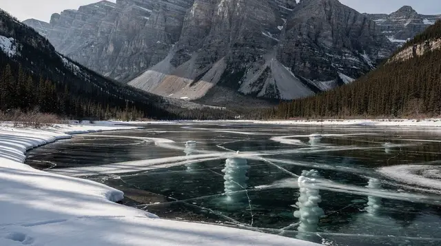
Winter changes the character of the stop completely: all three lakes freeze over, so the reflection disappears, but the road stays open and plowed, and the frozen lake surface with Mount Rundle behind it is its own kind of photograph — just a different one. If reflections specifically are what you’re after, plan around the ice-free months; see when the lakes thaw for how that timing plays out across the region’s lakes generally, and why the lakes turn the colour they do if you’re wondering why Vermilion Lakes water reads more brown-green than the turquoise you’ll see at Lake Louise or Moraine Lake — these are shallow valley-floor lakes, not glacially fed the same way, so the colour mechanism is different.
Birdwatching and wildlife
The wetlands bordering the lakes are one of the more reliable birdwatching spots close to Banff townsite. Waterfowl are common through the ice-free months, ospreys nest and hunt over the water in summer, and bald eagles pass through often enough that it’s worth having binoculars ready rather than assuming you’ll see one anyway. Songbirds work the aspen and spruce along the shoreline, particularly at first light.
Elk and, less often, deer move through the same corridor, especially around dawn and dusk — part of why the Fenland Trail walking route feels different early in the morning than at midday. During the elk rut in September and October, bull elk can be genuinely aggressive, and this stretch of valley floor is exactly the kind of place they use. Keep at least 30 metres from elk and other ungulates, more if a bull is displaying, and never position yourself between a cow and her calf.
For the wider picture on what moves through this part of the valley and when, see our wildlife viewing map and timing guide and the Bow Valley Parkway wildlife route, which covers similar habitat a little further along the valley. General bear safety and etiquette still applies here even though this isn’t a backcountry trail — it’s still bear habitat.
What this stop is not
Worth stating plainly, because the shallow, calm-looking water leads some visitors to assume otherwise: the Vermilion Lakes are not a swimming spot, and there’s no boat rental, canoe launch, or cruise operating here. There’s no beach, no lifeguard, no designated swim area, and no infrastructure built for getting into the water at all. If a lake with a boat tour or a beach day is what you’re picturing, Lake Minnewanka’s scenic cruise east of town is the better match, and general canoeing and kayaking spots around the region point to where paddling actually happens.
The comparison below covers the three lakes closest to Banff townsite that get mixed up most often:
| Vermilion Lakes | Lake Minnewanka | Two Jack Lake | |
|---|---|---|---|
| Direction from Banff | West, ~2-4 km | East, ~9 km | East, ~11 km |
| Size | Small, shallow chain of three | Largest lake in the park, 21 km | Mid-sized |
| Boat tour or rental | None | Scenic cruise, May-Oct | Non-motorized rentals seasonally |
| Swimming | Not set up for it | Not really promoted; cold | Small day-use beach area |
| Main reason to visit | Sunrise/sunset reflections, birdwatching | Boat cruise, biggest-lake views | Quieter picnic and paddle spot |
If you’re deciding which of these to prioritize on a short trip, the short version is: Vermilion Lakes for a free, quick photo stop near town; Minnewanka or Two Jack if you want a boat on the water or a longer lakeside afternoon.
Combining it with the rest of Banff
Because it takes so little time, the Vermilion Lakes fit naturally onto a morning that also includes other close-in stops. Many visitors pair a sunrise visit here with breakfast back in town, then move on to Tunnel Mountain or the Banff Gondola for the rest of the morning. Cyclists often ride out via the Fenland Trail, loop the lakes, and continue on the Legacy Trail toward Canmore rather than turning back — see the Legacy Trail biking guide for that full route.
a guided day covering Banff’s gondolas and winter highlights is a reasonable option if you’d rather have a driver handle the close-in Banff stops — including views similar to what you get at Vermilion Lakes — while you focus on photos instead of navigating pull-offs yourself.
If sunrise photography is specifically the draw, a guided sunrise outing to Moraine Lake aims at the same golden window of calm light and empty roads, just at a lake further out that requires its own transport logistics. And for a fuller day that gets you out of the townsite entirely, a full-day Johnston Canyon and area sightseeing tour covers ground the Vermilion Lakes don’t — waterfalls and canyon trail rather than valley-floor reflections.
For planning beyond this one stop, our things to do in Banff on foot guide lays out how a stop like this slots into a walking-based day, and the one day in Banff itinerary shows where it fits if you’re building a single-day plan from scratch. If photography specifically is your focus, the Banff photography itinerary and our notes on photographing lakes with a phone versus a camera are both built around exactly this kind of quiet, low-effort viewpoint.
Practical notes before you go
A few things worth knowing before making the short trip out:
- No food or washrooms at any of the pull-offs — bring water, and use facilities in town first.
- No cell coverage gaps to worry about here — unlike the Icefields Parkway further north, you’re close enough to town that mobile service generally holds.
- Parking is informal, gravel shoulders rather than marked lots, so arrive early on a summer weekend if you want the closest spot to the best reflection angle.
- Dress for wind, especially by mid-morning — the valley floor channels air down from the mountains, and it’s noticeably cooler at the water’s edge than on Banff Avenue.
- This is still bear and elk country, even though it feels close to town. Keep bear spray accessible if you’re walking the Fenland Trail, and give wildlife the standard distance regardless of how tame an elk looks.
If your visit is built around wildlife or photography more broadly, our best day hikes by difficulty and wildlife viewing map and times guides point to other close-in options with a similar low-commitment profile, and Grassi Lakes over in Canmore is a comparable short, easy outing if you’re staying on that side of the valley instead.
Vermilion Lakes: frequently asked questions
Can you swim in the Vermilion Lakes?
No. The Vermilion Lakes are shallow, weedy, and not maintained as a swimming area — there’s no beach, no lifeguard, and no designated entry point. They exist as a scenic drive and viewpoint, not a recreational water site.
What’s the best time of day to visit the Vermilion Lakes?
Early morning, close to sunrise, usually gives the calmest water and the clearest reflection of Mount Rundle. The hour before sunset works too, though afternoon wind on the Bow Valley floor often ripples the surface by midday.
How do you get to the Vermilion Lakes without a car?
The lakes are close enough to walk or cycle from Banff townsite — roughly 20 to 30 minutes on foot or under 10 minutes by bike from Banff Avenue. Roam Transit doesn’t run a route directly along Vermilion Lakes Drive, so a car, bike, taxi, or rideshare covers the gap if you’re not walking.
Are the Vermilion Lakes good for birdwatching?
Yes. The wetlands around the lakes attract waterfowl, ospreys, and the occasional bald eagle, plus songbirds in the surrounding spruce and aspen. Bring binoculars; there are no viewing blinds or interpretive stops built for it.
Do the Vermilion Lakes freeze in winter?
Yes, all three lakes freeze over in winter. The road stays open and plowed, so you can still drive or walk it for the mountain views, though the water itself and the reflections are gone until spring melt.
Are the Vermilion Lakes the same as Lake Minnewanka or Two Jack Lake?
No. Those two lakes sit east of Banff townsite, are much larger, and Lake Minnewanka runs a seasonal scenic boat cruise. The Vermilion Lakes are west of town, shallow, and have no boat launch or cruise operation — they’re a separate stop with a different purpose.
Is there an entrance fee for the Vermilion Lakes?
There’s no separate fee. The lakes sit inside Banff National Park, so the standard Parks Canada day pass or annual Discovery Pass that covers your visit to Banff also covers the Vermilion Lakes.
Can you cycle around the Vermilion Lakes?
Yes. Vermilion Lakes Drive is paved and low-traffic, and it connects to the Fenland Trail and the Legacy Trail network, making it one of the easier short rides from Banff townsite — flat, scenic, and without the climbs that Tunnel Mountain or Sulphur Mountain routes involve.