Abraham Lake ice bubbles: how and when to see them
When can you see the ice bubbles at Abraham Lake?
The frozen methane bubbles at Abraham Lake are typically visible from around mid-January to mid-February, but the exact window shifts every year with freeze timing and snowfall. The lake sits outside Banff and Jasper national parks on the David Thompson Highway, roughly 3 hours from Banff, so no Parks Canada pass is required to see it.
The strangest ice in the Rockies isn’t in a national park
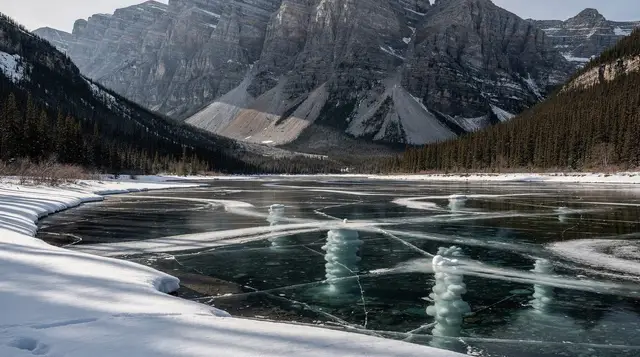
Most of what draws people to this region sits inside Banff or Jasper national park, which means a Parks Canada pass and a fee that scales by the day. Abraham Lake is the exception. This reservoir on the North Saskatchewan River sits well east of the park boundary, along the David Thompson Highway (Highway 11), and viewing it costs nothing beyond your own transportation. What you’re driving out for is not a mountain or a waterfall but a texture: white discs of frozen methane, stacked in the clear ice like a photograph of gas mid-bubble, frozen before it could reach the surface.
It photographs unlike almost anything else in the Rockies, which is exactly why it has become a fixture on winter itineraries out of Banff and Calgary in recent years. It’s also one of the easiest phenomena in this guide to misunderstand: it is not guaranteed on any specific date, it is not risk-free to approach, and it is not close. Treat it as a deliberate day trip, not a detour.
What’s actually happening in the ice
Abraham Lake is a reservoir, created in the 1970s when the Bighorn Dam impounded the North Saskatchewan River. The organic matter flooded at that time, along with plant material that continues to settle on the lake bed, decomposes and releases methane gas. In summer that gas simply bubbles up through open water and dissipates. In winter, it rises into ice that is actively forming from the surface down, and each bubble freezes in place the moment it meets that growing ice layer. As the ice thickens night after night, more bubbles get trapped at slightly deeper levels, which is why the classic photographs show stacks of discs rather than a single flat layer.
The reservoir’s depth, its relatively shallow organic-rich margins, and the wind that scours snow off sections of the ice all help explain why Abraham Lake shows this effect so much more dramatically than most other lakes in the region, which freeze over too but rarely stay clear and snow-free long enough to see through.
When to go, and why nobody can promise you a date
The reliable window is roughly the last two weeks of January through the first two weeks of February. Outside that range you’re gambling: too early and the ice isn’t thick enough to be safe or to have trapped many bubbles yet, too late and repeated snowfalls usually bury the clear ice under an opaque white layer that hides everything underneath.
Within that window, conditions still swing year to year and even week to week. A single snowfall can cover the best sections for the rest of the season. Wind, which is almost constant on this stretch of highway, can just as easily scour a fresh layer of snow off the ice and expose bubbles that were invisible the week before. Nobody, including tour operators who run this route weekly, can guarantee what a specific date will look like a month out. If you’re building a trip around this one sight, build in a spare day or a backup destination, and treat any date-specific promise you read online with scepticism.
Getting there from Banff
Abraham Lake sits about 215 kilometres from Banff, close to 3 hours of driving each way via the David Thompson Highway. That is a genuine day trip, not a side stop, and most of it runs through open, exposed terrain with long stretches between services. This guide won’t repeat the general rules for driving Alberta’s winter highways; for tire requirements, road conditions, and what to carry in the car, see our winter driving guide for the Rockies.
What’s specific to this stretch: fuel up before you leave, because services along Highway 11 are sparse and not guaranteed to be open. Cell coverage is patchy to non-existent for long sections, so download offline maps and let someone know your rough itinerary.
If your route also touches the Columbia Icefield or other stops inside Jasper National Park or Banff National Park, you’ll need a Parks Canada day pass for those legs — but not for Abraham Lake itself, which lies outside both parks. That’s a genuinely different rule from Kananaskis, which requires its own separate provincial pass; Abraham Lake requires neither.
For a broader sense of what a winter month in the region looks like before you commit to dates, see our month-by-month winter guide.
Getting onto the ice safely
This is the part visitors most often underestimate. Abraham Lake is a large, wind-exposed reservoir, and the ice that forms on it is not uniform. Thickness varies by section, current beneath the surface can thin ice unpredictably near inflow points, and snow drifts can hide cracks or soft patches until you’re standing on them. None of this means the lake is off-limits — thousands of people walk out onto it safely every winter — but it does mean the approach should be deliberate, not casual.
A few points that matter more here than at a groomed rink:
- Check conditions before you go. Ice thickness and safety vary through the season and even through a single week of weather. Local outfitters and recent trip reports are more current than any blanket rule.
- Wear ice cleats or grippers, not just winter boots. The ice surface where bubbles are visible is often bare and polished by wind, and it is genuinely slick.
- Wind is the bigger hazard for most visitors, not the ice. This stretch of highway is known for sustained, bitter wind with nothing to block it. Dress for wind chill well below the air temperature, and don’t linger for a long shoot if you’re underdressed.
- Go with others, and go in daylight. This isn’t a spot to visit solo after dark, and there’s no cell signal to rely on if something goes wrong.
- Respect closures and posted advice. Sections of ice can be deemed unsafe in a given week even if others nearby are fine.
If you’d rather not manage all of this yourself on a first visit, a guide who checks conditions daily and knows the current safe sections removes most of the guesswork.
Guided tours: the easier way to see it
Because the ice bubbles depend on conditions that change through the season, and because the drive itself is long and exposed, a guided day trip is a reasonable option even for travellers who are comfortable driving in winter. Several operators run this route specifically for the bubbles.
A winter day trip from Calgary built specifically around the ice bubbles and the lakes along the way covers the full return drive with a guide who knows which sections of ice are currently clear, which removes the guesswork on a first visit. For travellers already based in the mountains, a tour that pairs a stretch of the Icefields Parkway with a stop at Abraham Lake, departing from Canmore or Banff avoids backtracking through Calgary.
There’s also a pickup option that spans the main towns in one loop: a small-group ice bubble hunt with pickup from Calgary, Banff, or Canmore, useful if your group is staying in different places. And for travellers who want to combine the lake with other stops along the same highway corridor, a day trip that adds Tangle Creek and Mistaya Canyon to an Abraham Lake visit makes better use of the long drive.
Whichever option you choose, a guided trip effectively outsources the two hardest parts of a DIY visit: knowing where the ice is currently good, and managing the long, exposed drive in winter conditions.
DIY versus guided: what you’re actually weighing
| Self-drive | Guided day trip | |
|---|---|---|
| Round-trip distance from Banff | ~430 km | Same, but someone else drives |
| Local ice knowledge | You research and judge conditions yourself | Guide checks conditions regularly |
| Flexibility on timing | Full control over departure and stops | Fixed schedule, set pickup times |
| Winter driving required | Yes, on an exposed rural highway | No |
| Typical cost | Fuel and vehicle costs only | Tour price, varies by operator and inclusions |
| Best for | Confident winter drivers with their own vehicle | First-time visitors, those without a car, or anyone wary of the drive |
Neither option guarantees ice conditions on a given day; that variable is the same for everyone regardless of how you get there.
What to bring
Beyond the general winter packing advice covered elsewhere on this site, a few things are specific to a day at Abraham Lake: ice cleats, a windproof outer layer, spare camera batteries kept warm against your body until you need them, sunglasses for the glare off the ice on clear days, and a thermos of something hot. If you’re shooting for sunrise, add a headlamp and expect the wind chill to be sharper than the forecast air temperature suggests. For a broader packing list across seasons, see our summer and winter packing guide, and for a sense of just how cold this region gets in January, see what minus 25 actually feels like here.
Other stops along the David Thompson Highway
The drive out passes a few things worth folding into the same day if you have the time and the weather cooperates. Mistaya Canyon and Saskatchewan River Crossing sit near the junction with the Icefields Parkway, and Tangle Creek and the Columbia Icefield are reachable if you continue north rather than turning back toward Banff — see our guide to visiting the Columbia Icefield and our overview of the Icefields Parkway in winter if you’re combining the two. Note that those stops sit inside Banff or Jasper national park, so the Parks Canada pass rule applies there even though it doesn’t at Abraham Lake itself.
If you’d rather turn this into a broader winter theme instead of one long round trip, consider pairing it with a night of aurora-watching odds explained in our guide to the northern lights in the Rockies, or with the ice walks at Johnston Canyon and Maligne Canyon, which are far closer to Banff and don’t require the same long drive.
Where to base yourself for this trip
Most visitors do Abraham Lake as a single long day from wherever they’re already staying. Canmore shaves a little driving time off a Banff departure, while Calgary is a workable base too if you’re flying in and out through YYC rather than staying in the park itself. Whichever town you choose, budget the whole day for this trip; treating it as a quick add-on to another outing along the same highway usually means arriving or leaving in the dark.
Abraham Lake ice bubbles: questions worth settling before you go
What causes the bubbles trapped in Abraham Lake’s ice?
Decaying plant matter on the lake bed releases methane gas. In winter, that gas rises through the water and freezes into the ice layer by layer before it can escape, creating the stacked white discs and streaks that make this lake distinctive.
When is the best time to see the ice bubbles?
Roughly mid-January through mid-February gives the best odds, once the ice is thick and clear but before heavy snow covers it. The window shifts with each year’s freeze-up and snowfall, so there’s no fixed date that works every season.
Do I need a Parks Canada pass to visit Abraham Lake?
No. The lake sits outside Banff, Jasper, Yoho, and Kootenay national parks, so the Parks Canada day pass isn’t required for this stop specifically. You will need it for any leg of the trip that passes through the Icefields Parkway inside the parks.
Is it safe to walk out onto the ice to photograph the bubbles?
Ice thickness needs to be checked, not assumed. It varies across the lake, snow can hide cracks, and wind is often severe with no shelter nearby. Many visitors choose a guide for a first visit; nobody should go out alone or after dark.
Can I visit Abraham Lake on a guided day trip from Banff?
Yes. Operators run winter day trips from Banff, Canmore, and Calgary built specifically around the ice bubbles, often pairing the lake with stops at Tangle Creek, Mistaya Canyon, or other points along the David Thompson Highway or Icefields Parkway.
How far is Abraham Lake from Banff?
About 215 kilometres, roughly 3 hours by car via the David Thompson Highway. There’s no public transit link, so a rental car or a guided tour are the practical options.
What should I bring to photograph the ice bubbles?
Ice cleats, a windproof outer layer over your regular winter clothing, spare camera batteries kept warm, sunglasses for glare, and a headlamp if arriving for sunrise. Cell coverage along this route is unreliable, so download maps ahead of time.
Snowshoeing, ice walks & winter tours on GetYourGuide
Verified deep-linked GetYourGuide tours. Book through these links and we earn a small commission at no cost to you.
GetYourGuide does not provide a product photo for this activity — the image shows the meeting point, photographed by us.