Marble Canyon: the short walk over Kootenay's narrowest gorge
What is Marble Canyon and how long does the walk take?
Marble Canyon is a short interpretive trail in Kootenay National Park, British Columbia, crossing a series of bridges over a narrow limestone gorge carved by Tokumm Creek. The walk to the final bridge and back is about 1.6 kilometres round trip, roughly 30 to 45 minutes at an easy pace, but it's a 90-minute drive each way from Banff, so it isn't a quick roadside detour.
A narrow crack in the rock, not a warm-up for Paint Pots
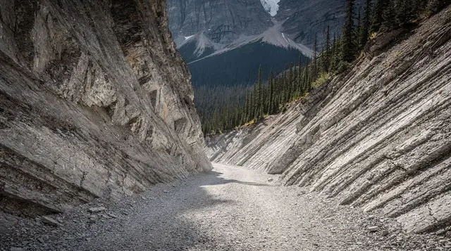
Marble Canyon sits just inside the British Columbia boundary of Kootenay National Park, a short but genuinely dramatic gorge where Tokumm Creek has cut down through limestone and dolomite over thousands of years, in places leaving a channel barely a few metres wide but more than 30 metres deep.
A series of bridges cross back and forth over the gorge as it narrows, giving you a straight look down into water most visitors describe as louder and closer than they expected from a trail this short. It’s often bundled into itineraries as a quick add-on to Paint Pots or Radium Hot Springs, and that undersells it: the canyon itself is worth the stop on its own, and this guide covers only Marble Canyon. Paint Pots and Radium Hot Springs, both nearby, each have their own coverage elsewhere on this site.
The trap with Marble Canyon is treating it as a five-minute detour you can slot into an already packed Banff day. It isn’t. The trailhead is inside Kootenay National Park, which means a Parks Canada day pass is required to stop here at all, and the drive from Banff eats up most of three hours round trip before you’ve walked a step. Plan for it honestly and it’s a satisfying half-day; plan for it as an afterthought and you’ll either skip it under time pressure or arrive without a pass displayed on your dash.
Getting there from Banff, and the pass you actually need
The route from Banff runs west on Highway 1 (the Trans-Canada) to Castle Junction, then south on Highway 93 South, signed as the Banff-Windermere Highway, through Kootenay National Park toward Radium Hot Springs. Marble Canyon’s parking area and trailhead sit directly off this highway, well signed, roughly 100 kilometres from Banff townsite and about 90 minutes of driving under normal conditions.
That’s the number worth sitting with before you commit to a same-day trip. A 90-minute drive each way means three hours of driving alone, before you’ve walked the canyon, before any stop at Paint Pots or Radium Hot Springs, and before the drive back. Treating Marble Canyon as something you can “just pop into” from Banff on a morning that already has other plans is how people end up rushing the walk or arriving after the light has gone flat. Our guide to what isn’t a realistic day trip from Banff covers this pattern more broadly; Marble Canyon on its own is doable in a day, but only if it’s the plan, not an add-on.
The pass question catches people out specifically because Marble Canyon doesn’t look like a park entrance. There’s no gate, no booth, nothing that visually says “you are now inside a national park requiring a pass.” But the boundary of Kootenay National Park runs along this highway well before the Marble Canyon turnoff, and the parking area itself sits inside it.
A valid Parks Canada day pass, purchased in advance or at a park gate elsewhere, or a Discovery Pass covering the year, is legally required to park and walk here, exactly as it would be at any trailhead in Banff or Yoho. Parks Canada staff do check vehicles at Kootenay trailheads, including Marble Canyon, and an unlicensed stop can mean a ticket rather than a warning. Our Parks Canada pass guide covers current pricing and where to buy one before you leave Banff, which is simpler than trying to sort it out at the trailhead itself.
| From Banff | Distance | Driving time |
|---|---|---|
| Castle Junction (Highway 1 / 93 split) | ~30 km | ~25 min |
| Marble Canyon trailhead | ~100 km | ~90 min |
| Paint Pots trailhead | ~110 km | ~95 min |
| Radium Hot Springs | ~135 km | ~1 h 45 |
The walk itself: bridges, distance, and where to stop
From the parking area, the trail follows Tokumm Creek upstream on a wide gravel and boardwalk path, gaining a little elevation as it goes. Interpretive signs along the way explain the geology, and the canyon narrows visibly the further you walk, with the creek dropping further below the bridges at each crossing.
There are seven numbered bridges in total, each crossing the gorge at a slightly different point and angle. The first two or three are close to the parking area, wide, and manageable for almost anyone, including strollers on a good-weather day. Past that point the path narrows, gains a short run of steps, and the drops on either side of the bridges get more pronounced, which is part of the appeal but also worth knowing if you’re travelling with young kids or anyone uneasy with height and exposed edges. The final bridge crosses directly over a waterfall plunging into the narrowest section of the canyon, arguably the best single viewpoint on the trail, and a natural turnaround point for most visitors.
| Point on the trail | Approx. distance from parking (one-way) | Notes |
|---|---|---|
| Bridge 1–2 | ~150 m | Wide, flat, easiest section |
| Bridge 3–4 | ~350 m | Canyon narrows, more exposure |
| Bridge 5–6 | ~600 m | Steeper drops below the bridges |
| Bridge 7 (waterfall viewpoint) | ~800 m | Usual turnaround point |
Round trip to the final bridge and back runs about 1.6 kilometres, which most visitors cover in 30 to 45 minutes including stops for photos and reading the signage. It’s a short walk by Rockies standards, shorter than a full circuit of Emerald Lake or an afternoon at Kicking Horse River, but it isn’t a stop you should try to do in five minutes flat; the narrow sections and bridge crossings reward slowing down rather than rushing to the far end and back.
Best times to visit, and what the crowds look like
Marble Canyon is busiest in July and August, in the middle of the day, when it picks up overflow traffic from visitors doing a Banff-to-Radium loop or a Kootenay day trip. The parking area is not large, and on peak summer afternoons it can fill, leaving vehicles parked along the highway shoulder. Arriving before mid-morning or after late afternoon avoids most of this, and also gives better light for photographing the canyon, since the gorge itself sits in shadow for a good part of the day.
Shoulder season, from late May through June and again in September, sees noticeably fewer people and the same canyon. The creek runs higher and louder in late spring from snowmelt, which some visitors prefer for the sound and spray; by September the flow drops and the water clarity improves, making the pools below the bridges easier to see.
Winter: a different canyon entirely
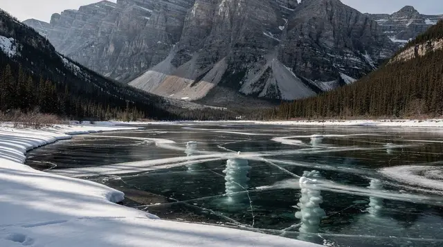
The highway through Kootenay National Park stays open year-round, and Marble Canyon’s trail and parking area remain accessible, but winter changes the experience substantially. Spray from the creek freezes onto the bridges, railings, and boardwalk sections, and Parks Canada does not run the same level of surface maintenance here through the colder months that it does in summer. The narrower sections past the first few bridges can turn into solid ice with no visible warning from a distance.
Traction devices for footwear are strongly advised from November through April; this is the same advice that applies at Johnston Canyon in Banff, and for good reason, since both canyons ice up in similar ways. Several operators run a combined guided ice walk pairing Marble Canyon with Johnston Canyon in the same outing, with crampons supplied, which removes the guesswork of judging ice conditions yourself:
a guided ice walk combining Marble Canyon and Johnston CanyonWhat’s nearby, and what this guide deliberately leaves out
Marble Canyon sits along a stretch of Highway 93 South that also holds two other well-known stops, both covered in their own detail elsewhere on this site rather than here. Paint Pots, about 10 minutes further down the highway, is a short walk to ochre-stained mineral springs the Ktunaxa and other nearby First Nations traditionally used as a pigment source. Radium Hot Springs, another 30 to 40 minutes on, is a developed hot spring pool at the park’s western edge. Both are easy to add to the same day as Marble Canyon, since they’re on the same road, but each deserves its own planning rather than being treated as a five-minute stop bolted onto this one.
Further afield, Golden and the Kicking Horse River sit about 45 minutes past Radium Hot Springs, home to the suspended walkways of the Golden Skybridge and whitewater rafting on a river fed by glacier melt from the Wapta Icefield. That’s a genuinely separate day from Marble Canyon rather than something to fold into the same trip.
Combining Marble Canyon into a longer Kootenay day
Most visitors don’t drive 90 minutes for a 30-minute walk alone, and a handful of day tours are built around exactly this stretch of highway, bundling Marble Canyon with Radium Hot Springs, Emerald Lake, or a wider loop through Kootenay and Yoho. A guided day trip removes the pass question entirely, since it’s included, and it means someone else is doing the 90-minute drive each way:
a day trip pairing Marble Canyon with Radium Hot SpringsFor visitors basing themselves at Lake Louise rather than Banff townsite, a tour running from that end of the valley can shave time off the approach, folding Marble Canyon into a loop through Yoho as well:
a Lake Louise-based tour covering Marble Canyon and Emerald LakeIf you’d rather build your own itinerary around Kootenay and Yoho over several days instead of a single rushed loop, our five-day Banff, Yoho, and Kootenay itinerary spreads these stops out with room to actually stand at each one rather than checking it off.
Practical details before you go
| Detail | What to know |
|---|---|
| Park pass | Required, no exceptions for a short stop; buy before you leave Banff |
| Parking | Free, but a small lot that fills on summer afternoons |
| Surface | Gravel and boardwalk, several short flights of stairs |
| Washrooms | Vault toilets at the parking area, no other facilities |
| Cell coverage | Unreliable to absent through this section of highway |
| Dogs | Permitted on leash |
| Accessibility | First two bridges are manageable for most mobility levels; the trail narrows and steepens beyond that |
| Fuel | Fill up in Banff or Radium Hot Springs; no services at the trailhead |
There’s no food service, gift shop, or visitor centre at Marble Canyon itself, just the parking area, the toilets, and the trail. Bring water and whatever food you need for the drive, since the nearest services in either direction are a genuine drive away, not a five-minute walk.
Marble Canyon FAQ: distance, pass, and what to expect
How far is Marble Canyon from Banff?
Roughly 100 kilometres, about 90 minutes of driving via Highway 1 west to Castle Junction, then south on Highway 93 South (the Banff-Windermere Highway) through Kootenay National Park. It’s closer to Banff than Radium Hot Springs, which sits a further 35 kilometres down the same highway, but it’s still a three-hour round trip on driving alone.
Do you need a park pass just to stop at Marble Canyon?
Yes. Marble Canyon is inside Kootenay National Park, and a valid Parks Canada day pass or Discovery Pass is required even for a short stop at the trailhead, the same pass system that covers Banff, Jasper, and Yoho. There’s no separate gate or ticket booth checking at Marble Canyon itself, but rangers do patrol and issue fines to vehicles without a displayed pass.
How long is the Marble Canyon trail and is it difficult?
The main trail is about 800 metres one-way to the final bridge over the waterfall, so 1.6 kilometres return, on a wide, mostly flat gravel and boardwalk path with a handful of short steps. It’s an easy walk suitable for most fitness levels and manageable with a stroller as far as the first few bridges, though the surface narrows and the drops get steeper closer to the end.
Why is it called Marble Canyon if the rock isn’t marble?
The pale grey and white rock walls of the canyon are dolomite and limestone, not true marble in the geological sense, but the polished, banded look of the water-smoothed rock resembles marble closely enough that the name stuck. It’s a common naming pattern in the Rockies, where visual resemblance wins out over strict mineralogy.
Can Marble Canyon be combined with Paint Pots or Radium Hot Springs in one trip?
Yes, and most visitors do exactly that, since all three sit along the same stretch of Highway 93 South. Paint Pots is a separate trailhead about 10 minutes further south, and Radium Hot Springs is another 30 to 40 minutes beyond that. Treat the three together as a half-day to full-day outing rather than three quick stops, since the driving adds up faster than the walking does.
Is Marble Canyon open in winter?
The trail and highway stay open year-round, but conditions change completely. The bridges and boardwalks ice over, spray from the creek freezes onto railings and rock, and Parks Canada does not run summer-level maintenance on the path in winter. Traction devices for footwear are strongly advised from November through April, and the guided ice walk combo pairs Marble Canyon with Johnston Canyon for exactly this season.
Canyon walks & waterfall tours on GetYourGuide
Verified deep-linked GetYourGuide tours. Book through these links and we earn a small commission at no cost to you.
GetYourGuide does not provide a product photo for this activity — the image shows the meeting point, photographed by us.