A flat canyon walk that doesn’t ask much of you
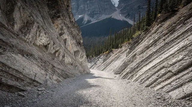
Grotto Canyon is the rare Rockies outing that delivers a genuinely narrow slot canyon, a wall of centuries-old rock art, and a round trip under two and a half hours, without asking for a single steep switchback. The trail follows a dry streambed cut into limestone just east of Canmore, off Highway 1A near the hamlet of Exshaw, and it’s flat enough for most of its length that families with kids old enough to manage loose rock and the occasional boulder step routinely make it work as a half-day outing.
That’s also its limit — this isn’t a summit hike or a lake hike, and if you’re after either of those, Grassi Lakes or Ha Ling Peak are the better picks nearby, each with its own trail and its own page.
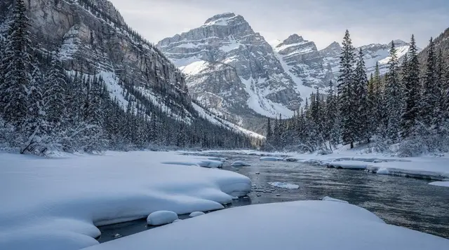
The draw here is specific: a canyon that narrows to a rocky corridor, ochre pictographs painted on the limestone where that corridor pinches tightest, and — in winter only, and only with the right gear — a frozen waterfall at the canyon’s head that draws crampon-clad ice walkers rather than casual hikers. None of that requires technical skill in summer. It does require honesty about what changes once the temperature drops, which is the part most casual write-ups skip.
Getting there and what it costs
Grotto Canyon sits about 35 kilometres from Banff, roughly 30 to 35 minutes by car via Highway 1 and then Highway 1A, passing through or around Canmore on the way. The trailhead itself is a small gravel pull-off on Highway 1A a few kilometres past Canmore, near the Baymag plant close to Exshaw — it’s easy to miss on a first pass, so slow down once your GPS says you’re close.
Because the canyon sits outside Banff National Park’s boundary, you do not need a Parks Canada pass to hike it, unlike almost everywhere else covered on this site — see Parks Canada pass explained for where that pass does and doesn’t apply.
It also falls outside the area that requires the separate Kananaskis Conservation Pass, so parking at the trailhead is free, first-come, first-served, and can fill on summer weekends by mid-morning. There are no washrooms, no water, and unreliable cell coverage at the trailhead — plan accordingly and treat it as a self-sufficient outing, same as any other stop covered in bear safety and etiquette.
| Item | Cost |
|---|---|
| Trailhead parking | Free |
| Park or conservation pass | None required |
| Guided small-group hike | Roughly 90-130 CAD per person |
| Guided winter ice walk | Roughly 100-160 CAD per person, gear typically included |
The walk itself
From the trailhead, the trail drops briefly to the dry streambed and then follows it upstream, staying mostly flat with only around 75 metres of total elevation gain across the whole out-and-back. The out-and-back to the main pictograph panel and the narrows just beyond it comes to about 4.3 kilometres round trip, and most parties cover it in 1.5 to 2.5 hours including stops. That puts it in the same easy bracket as Tunnel Mountain, though the terrain here is rockier underfoot and less of a maintained tread — expect to step over and around boulders rather than walk a groomed path the entire way.
For most of the summer, the creek that carved this canyon runs underground or dries up entirely, which is why the walking surface is a bed of smooth, water-worn rock rather than a stream crossing. That changes during spring melt or after a heavy rain, when a short stretch near the Highway 1A end can hold standing water or a thin flow — nothing that stops a hike, but worth expecting wet feet if you’re there right after a storm. The canyon narrows noticeably as you go, with limestone walls closing in until the corridor is only a few metres wide at its tightest point, which is also where the pictographs appear.
Because the trail is unmaintained gravel and rock rather than pavement or boardwalk, it isn’t stroller-friendly beyond the first few hundred metres, and anyone with significant mobility limitations should expect the boulder-hopping sections to be genuinely difficult. Sturdy shoes matter more here than on most of the easy trails on this site — sandals and the loose rock underfoot don’t mix.
The pictographs
Roughly 1.5 kilometres in, where the canyon narrows toward the pictograph panel, faint ochre-red figures appear painted directly onto the limestone wall. Some estimates place the oldest of these markings at over a thousand years old, based on the pigment and weathering rather than any written record, and archaeologists have not attached a single, certain authorship to them.
What’s known with more confidence is the broader context: this stretch of the Bow Valley lies within Treaty 7 territory, home to the Stoney Nakoda (Îyârhe Nakoda) and the Blackfoot Confederacy — Siksika, Kainai and Piikani — along with the Tsuut’ina, and the region’s Indigenous history long predates any of the roads or trail markers you’ll walk past to get here. For more on that context, see Indigenous history and experiences in Banff.
Treat the panel the way you’d treat any fragile cultural site: look, don’t touch, and don’t add your own marks nearby, however tempting a smooth rock face might look. There’s no fence or ranger station here — the only protection the pictographs have is visitors choosing not to damage them.
The frozen waterfall — winter only, and only with the right gear
At the head of the canyon, past the pictograph narrows, a modest waterfall spills over a limestone step. In summer it’s a trickle, easy to miss. From roughly December through March, when temperatures hold well below freezing, that same waterfall builds into a thick curtain of ice, and it’s this ice — not the summer streambed — that draws a different crowd entirely: ice walkers and ice climbers in crampons, working the frozen falls and the icy streambed leading up to it.
This is the piece of Grotto Canyon that’s easiest to oversell and easiest to get wrong. The whole approach, not just the waterfall, can turn to hard-packed or glare ice once cold weather sets in, and the same boulders that are a minor scramble in July become a genuine slipping hazard under a skin of ice in January. Microspikes are the practical minimum for anyone attempting it independently; full crampons are what guided groups typically use for the ice section itself.
This is not a hike you can do in winter runners, and it is not automatically safe just because the summer version is easy — conditions shift year to year and week to week depending on freeze-thaw cycles, so what worked for a friend’s trip last February isn’t a guarantee for yours. Most visitors who want the frozen waterfall book a guided ice walk rather than heading out solo, which covers the crampons, the route-finding, and current ice conditions in one booking.
a guided winter ice walk into Grotto Canyon takes care of the gear and the judgment calls that make the difference between a scenic frozen corridor and a slippery, marginal one. For comparison, the region’s other well-known cold-season canyon walks are covered in Johnston Canyon and Maligne Canyon ice walks, and general cold-weather planning is in what minus 25 really means.
Doing it yourself in summer
If you’re visiting between May and October, no booking or guide is needed. Bring water, sun protection, and shoes with real tread, and budget 1.5 to 2.5 hours for the round trip to the narrows and back. Weekday mornings are noticeably quieter than weekend afternoons, when the small trailhead lot fills and cars start lining the highway shoulder.
A few practical points that don’t make it onto most trail summaries: the canyon walls hold shade for a good part of the day, so temperatures inside the narrows can feel noticeably cooler than the parking lot even in July, worth knowing if you packed for heat. There’s no formal signage marking the pictograph panel itself, so it’s easy to walk past it the first time — look for the point where the walls close in tightest and scan the rock face at roughly eye to head height rather than higher up.
Bear activity is possible along this stretch of the Bow Valley the same as anywhere else in the region, so carrying bear spray and making noise on the approach is sensible even on a short, easy trail like this one. And because much of the route is bare rock rather than packed earth, it holds heat and glare on a sunny afternoon — an earlier start is more comfortable than a midday one for exactly that reason, quite apart from the parking situation.
For visitors who’d rather have the pictographs and the geology explained rather than work it out from a trailhead sign, a small-group tour pairing Grassi Lakes with Grotto Canyon covers both trails in one guided outing from Banff. Neither trail requires a guide to complete safely in summer conditions — this is for travellers who prefer the context and logistics handled for them.
Combining it with the rest of the day
Because the whole outing takes half a day at most, most visitors pair it with time in Canmore itself, whose cafés, breweries and shops sit about 15 minutes away by car — see Canmore in one day for how to fill the rest of the schedule. Grotto Canyon also shows up on broader scenic itineraries around the Bow Valley; a Canmore and Banff National Park scenic lakes tour is one option if you’d rather see Grotto Canyon as one stop among several rather than the focus of the day.
For a wider list of similarly gentle trails in the area, see easy, accessible trails near Banff and the broader hiking in Banff itinerary. A full write-up of the trail itself, including turn-by-turn notes from the trailhead, is in the Grotto Canyon hike guide.
Grotto Canyon, Grassi Lakes and Ha Ling Peak
It’s worth being clear about what Grotto Canyon isn’t, since the three most popular easy outings near Canmore get mixed up constantly. Grotto Canyon is flat, dry in summer, and built around pictographs and a slot canyon. Grassi Lakes climbs to two small turquoise ponds with meaningfully more elevation gain. Ha Ling Peak is a genuine, steep summit hike with a real workout attached, nothing like the other two. If your group has mixed fitness levels or young kids, Grotto Canyon is the one that asks the least of everyone, while Ha Ling Peak is the one to skip unless everyone in the group actually wants a climb.
| Trail | Distance | Elevation gain | Character |
|---|---|---|---|
| Grotto Canyon | 4.3 km return | Around 75 m | Flat streambed, pictographs, frozen falls in winter |
| Grassi Lakes | Around 4 km return | Around 200 m | Moderate climb to two ponds |
| Ha Ling Peak | Around 6.8 km return | Around 700 m | Steep summit scramble, real elevation |
Frequently asked questions about Grotto Canyon
How long is the Grotto Canyon hike?
The standard out-and-back to the pictograph panel and the narrows beyond it runs about 4.3 kilometres round trip, with only around 75 metres of elevation gain. Most people finish in 1.5 to 2.5 hours, including stops to look at the rock art.
Do I need a Parks Canada pass for Grotto Canyon?
No. Grotto Canyon sits outside Banff National Park, off Highway 1A near Exshaw, so no Parks Canada pass is required. It’s also outside the boundary that requires a Kananaskis Conservation Pass — parking at the trailhead is free.
Where are the pictographs and how old are they?
Ochre-painted figures appear on a limestone wall roughly 1.5 kilometres in, where the canyon narrows. Some estimates put the oldest markings at over a thousand years old, but no single group has been definitively attributed as their sole author, and the site should be treated with the same respect as any other cultural heritage location — viewed, not touched.
Is Grotto Canyon dry in summer?
Yes, for most of the summer the creek that carved the canyon runs underground or not at all, leaving a rocky, walkable streambed. Expect some standing water or a short wet section after heavy rain or during spring melt, particularly close to the Bow Valley Trail end.
Can you hike Grotto Canyon in winter?
You can, but conditions vary widely and casual footwear isn’t enough once ice sets in over the streambed and around the frozen waterfall at the canyon’s end. Microspikes or crampons are the practical minimum, which is why most winter visitors join a guided ice walk rather than heading out alone.
Is Grotto Canyon the same hike as Grassi Lakes?
No, they’re separate trails that happen to sit near each other outside Canmore. Grotto Canyon is a flat streambed walk with pictographs; Grassi Lakes is a shorter climb to two turquoise ponds with more elevation gain. Some guided tours combine both in a single outing.
Do I need a guide to visit Grotto Canyon?
No guide is required for the summer streambed walk, which is well within reach of an unguided family outing. A guide becomes worth considering in winter, when route-finding over ice and the frozen waterfall section benefit from someone who knows current conditions and carries the right gear.
Is there parking and washrooms at the trailhead?
There’s a small gravel parking area off Highway 1A with no washrooms, no water, and no cell coverage to count on. The closest facilities and food are back in Canmore, about 15 minutes away by car.