Grotto Canyon hike: pictographs and a seasonal waterfall near Canmore
What is the Grotto Canyon hike near Canmore?
Grotto Canyon is an easy 5 to 8 kilometre return walk along a dry creek bed east of Canmore, leading to a rock wall with ancient ochre pictographs and a small seasonal waterfall that freezes into an ice-walk destination in winter. It sits outside Banff National Park, so no Parks Canada pass is needed, and the pictographs are fragile enough that touching or approaching the rock face is discouraged.
Most day hikers coming from Banff have never heard of Grotto Canyon, and that is partly why it is worth mentioning: it gets a fraction of the traffic of the lakes, and the walking is flat enough that the payoff (a rock wall painted centuries ago, and a canyon that narrows into a slot you can touch on both sides at once) does not cost you much in elevation gain.
Where Grotto Canyon is and how to get there
Grotto Canyon sits east of Canmore, off the Bow Valley Trail (Highway 1A), roughly 10 minutes past town if you are coming from that direction, or about 35 kilometres and 30 to 35 minutes from Banff. From Banff, the drive follows the Trans-Canada Highway to Canmore, then a short stretch of Highway 1A east toward Exshaw. There is a small gravel parking lot at the signed trailhead; it fills up on summer weekends by mid-morning, but rarely reaches the gridlock you get at Lake Louise or the Moraine Lake shuttle line.
This is a different corridor from the Grassi Lakes and Ha Ling Peak trailhead, which is on Smith-Dorrien Trail on the opposite side of Canmore. People sometimes assume all three hikes share a starting point because tour operators bundle them together; on the ground, they do not, and you cannot walk between them.
Grotto Canyon also sits outside the boundary of Banff National Park, in Bow Valley Wildland Provincial Park. That matters practically: you do not need a Parks Canada pass to hike here, and this is not the Kananaskis Conservation Pass zone either. Provincial fee areas do change, so a glance at the trailhead signage on the day is worth more than anything written here.
What the hike is actually like
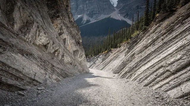
The trail follows the dry bed of Grotto Creek, a channel that only carries meaningful water during spring runoff and after heavy rain. For most of the year you are walking on gravel, cobbles, and bedrock rather than dirt trail, with the canyon walls closing in gradually as you go. Elevation gain is minimal, somewhere around 60 to 100 metres over the whole route, and there is no sustained climbing; the effort comes from picking your footing over uneven rock rather than from switchbacks.
About 1.6 kilometres in, the canyon narrows and a section of rock wall on the right holds the pictographs (more on those below). Most visitors turn around here, making for a return trip of roughly 3.2 kilometres and an hour or so at an easy pace.
If you keep going, the canyon narrows further into a slot section, in places narrow enough to touch both walls, before opening at a small amphitheatre with the seasonal waterfall. Pushing to that point and back brings the round trip to somewhere around 6 to 8 kilometres, with 2 to 3 hours a realistic estimate once you include stops for photos and scrambling over the larger boulders that collect in the creek bed after runoff seasons.
Worth knowing before you go: the 2013 Alberta floods reshaped much of this valley, including this creek bed, and channels like this one continue to shift after big runoff years or heavy summer storms. The exact footing and the size of the boulder piles can differ from what a photo online shows you; treat trail descriptions, this one included, as a general shape rather than a precise map.
| Detail | What to expect |
|---|---|
| Distance to pictographs | About 3.2 km return |
| Distance to waterfall/upper canyon | About 6 to 8 km return |
| Elevation gain | Roughly 60 to 100 m, mostly flat |
| Time | 1 hour to pictographs; 2 to 3 hours for the full route |
| Difficulty | Easy on the lower creek bed; short boulder scrambling higher up |
| Park pass required | None (outside Banff National Park) |
| Best surface footwear | Sturdy shoes or boots; the creek bed is uneven and sometimes wet |
The pictographs: what you’re looking at, and why you shouldn’t touch them
The rock art at Grotto Canyon is painted in red ochre on a limestone wall, a technique and pigment used across this region for a very long time; specific dating for this particular panel is not settled, and estimates you will see elsewhere range widely. What is agreed on is that this is a real cultural site connected to the peoples of Treaty 7, including the Stoney Nakoda (Îyârhe Nakoda), whose territory this valley falls within, alongside the Confederacy of the Blackfoot (Siksika, Kainai, Piikani) and the Tsuut’ina.
There is no fence, no interpretive staff, and no gate stopping anyone from walking right up to the wall. That absence of a barrier is not a signal that the site is robust; ochre pigment on exposed rock is inherently fragile, and every hand that touches the wall, every boot that scrambles up the talus toward it, adds wear that cannot be undone. Treat this the way you would a museum piece with no glass case: look, photograph from a respectful distance, and do not touch the rock face or attempt to climb toward the painted section. Read the site as it is, an ancient and still-significant place on Treaty 7 land, not as a photo backdrop.
For more context on the peoples and history connected to this landscape, see our overview of Indigenous history and experiences in Banff.
The seasonal waterfall (and why it isn’t always there)
Past the narrows, the canyon opens into a small amphitheatre where a waterfall drops over the back wall. Calling it seasonal is not a hedge: the flow depends entirely on snowmelt and rain feeding the upper drainage, so it typically runs from around May into early summer, and by August it can be reduced to a damp streak or nothing at all. If a summer visit is your only option, do not build the trip around seeing running water; build it around the canyon walls and the pictographs, which do not depend on the calendar in the same way.
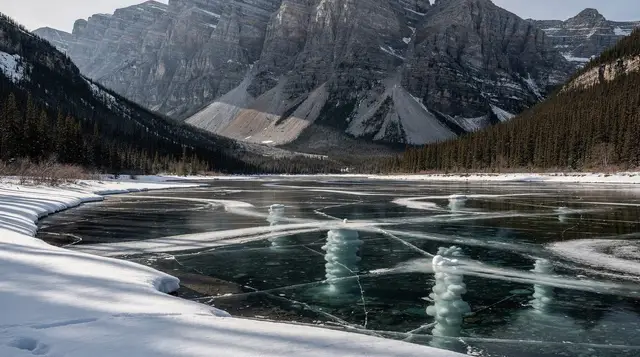
In winter, that same water freezes solid into a curtain of ice against the rock, and this is where Grotto Canyon becomes a different kind of destination entirely.
Winter: ice walks and crampons
Frozen, the upper canyon turns into one of the more accessible ice-walk routes near Banff and Canmore, usually feasible from around December through March depending on how cold the season runs. The appeal is real: walking a slot canyon with ice climbers’ formations overhead, at a fraction of the crowd of Johnston Canyon’s ice walk.
The catch is that the terrain changes character in winter. The boulders and creek bed that are merely uneven in summer get buried and glazed, and the narrow upper section can require short scrambles over frozen ground where a slip has real consequences. Doing this section solo without crampons is where people get hurt or turned around; a guided walk supplies crampons, sometimes a rope for the steeper pitches, and someone who has checked ice conditions that week rather than relying on a photo from last winter.
a guided winter ice walk through Grotto Canyon that also covers the pictograph site’s history is a reasonable way to see both the ice formations and the rock art safely in one outing, with equipment supplied. If you’re staying closer to Lake Louise, a guided crampon walk into the canyon runs from that side of the valley as well.
What to pack and when to go
Summer and shoulder season call for sturdy footwear rather than sandals; the creek bed is uneven cobble and rock, occasionally with a shallow trickle of water crossing the path, and ankle support matters more here than on a groomed trail. Bring more water than you think you need, since there is no shade for stretches of the lower canyon and no services at the trailhead.
Winter visits need actual traction, not just winter boots: microspikes at minimum for the lower creek bed, and full crampons if you are pushing into the icy upper narrows. A headlamp is worth carrying even for a daytime hike, since short winter days can catch people out on the walk back to the car.
This is bear country like the rest of the Bow Valley; carry bear spray, know how to use it, and check current trail advisories, since seasonal closures for wildlife activity do happen in this corridor. Our guide to bear safety and etiquette covers what to do if you encounter one.
| Season | What to expect |
|---|---|
| Spring (May–June) | Waterfall flowing, creek bed can be muddy and higher water |
| Summer (July–August) | Driest footing, waterfall often reduced or dry, warmest temperatures |
| Fall (September–October) | Cool, quiet, good light on the canyon walls |
| Winter (December–March) | Ice walk conditions in the upper canyon, crampons recommended |
Grotto Canyon vs Grassi Lakes vs Ha Ling Peak
These three hikes get bundled into the same day-tour itineraries out of Canmore, which is where the confusion starts. They do not share a trailhead and they are not interchangeable.
| Hike | Trailhead | Character | Difficulty |
|---|---|---|---|
| Grotto Canyon | Highway 1A, east of Canmore | Flat dry creek bed, pictographs, seasonal waterfall | Easy, some boulder scrambling upstream |
| Grassi Lakes | Smith-Dorrien Trail | Short climb to two turquoise ponds | Easy to moderate, steeper option available |
| Ha Ling Peak | Smith-Dorrien Trail (near Grassi Lakes) | Steep switchbacks to a summit ridge | Moderate to strenuous |
If your day only has room for one of the three and you want the least climbing, Grotto Canyon is the flattest of the group. If you want a view from a summit, Ha Ling is the one that delivers it, at a real cost in elevation gain.
Booking a guided tour vs going on your own
Grotto Canyon does not require a guide in summer; the trail is well-defined, the parking lot is signed, and the walk to the pictographs is straightforward enough for most fitness levels. Where a guide earns its cost is context and winter safety: someone who can point out the pictograph panel’s history accurately rather than let you guess, and who carries the crampons and rope for the icy upper canyon in winter.
a small-group day tour from Banff that combines Grotto Canyon with Grassi Lakes is a practical option if you do not have a rental car and want both hikes covered without arranging your own transport between the two trailheads. There is also a dedicated winter ice-walk tour into the canyon for visitors who specifically want the frozen waterfall experience rather than the summer version of the trail.
For a broader read on when a guide is worth the money versus when a rental car and a map serve you just as well, see our comparison of guided tour vs rental car and our notes on what guided hikes actually add.
Fitting Grotto Canyon into a longer visit
Grotto Canyon pairs naturally with a Canmore-based day, since it starts and ends near town rather than deep in the national park. If you are building out a full day around Canmore, our Canmore in one day guide lines up a realistic order of stops, and the broader hiking in Banff itinerary places this hike alongside other options if you are trying to decide where an easy day fits into a longer trip.
For a rundown of easy, low-commitment trails across the whole area, our easy and accessible trails guide and our best day hikes by difficulty breakdown both cover where Grotto Canyon sits relative to the rest of the region’s options, and things to do in Canmore rounds out what else is nearby if you have more than a morning to spend there.
Grotto Canyon hike FAQ
How long is the Grotto Canyon hike?
The walk to the main pictograph wall is about 1.6 kilometres each way on a flat, gravelly creek bed. Continuing into the narrower upper canyon to the seasonal waterfall stretches the round trip to roughly 6 to 8 kilometres, with 2 to 3 hours a realistic pace for most people, including stops.
Are the Grotto Canyon pictographs open all year?
The trail itself is open year-round, but the pictograph rock face is not a staffed or fenced site, and it can be reached in any season. That access is exactly why the site is fragile: there is no barrier stopping someone from touching or climbing near the paintings, so the responsibility not to falls entirely on visitors.
Do I need a park pass for Grotto Canyon?
No Parks Canada pass is required, because the trailhead and canyon sit outside the boundary of Banff National Park, in Bow Valley Wildland Provincial Park near Exshaw. Fee areas do shift over time, so it is worth a quick check of current Alberta Parks signage at the trailhead before you go.
Is Grotto Canyon the same hike as Grassi Lakes?
No. Grassi Lakes and Ha Ling Peak start from a separate trailhead on the other side of Canmore, off Smith-Dorrien Trail, and climb toward turquoise ponds or a summit ridge. Grotto Canyon starts from Highway 1A east of town and stays flat, following a creek bed rather than climbing a slope.
When does the Grotto Canyon waterfall actually flow?
The waterfall at the back of the canyon is fed by spring runoff and snowmelt, so it typically runs from around May through early summer and can slow to a trickle or dry up completely by late summer. In winter, the same water freezes into an ice curtain that guided ice-walk tours use for a controlled scramble with crampons.
Can I do Grotto Canyon in winter without a guide?
You can walk the lower creek bed on your own with good winter boots and traction aids, but the upper canyon narrows involve scrambling over ice-covered boulders and sometimes short sections of frozen waterfall, which is where unguided visitors get into trouble. A guided ice walk with crampons and a rope is the safer way to see that section between roughly December and March.
Is Grotto Canyon a good hike for kids or dogs?
The lower section to the pictographs is flat and manageable for most kids old enough to walk a couple of kilometres, and dogs on leash are common on the trail. The creek bed does involve stepping over rocks and occasional shallow water, so it suits sturdy footwear more than a stroller.
Canyon walks & waterfall tours on GetYourGuide
Verified deep-linked GetYourGuide tours. Book through these links and we earn a small commission at no cost to you.
GetYourGuide does not provide a product photo for this activity — the image shows the meeting point, photographed by us.